
Sometimes when you go for a long hike into the mountains, you never want to leave and come back. Today was one of those days – no clouds, no wind, no bugs, and spectacular views in every direction. In fact, I would rank this as one of the most outstanding hikes I’ve had in Switzerland – second only to that amazing night on Faulhorn last fall. Today I was inspired by a post from another blogger to return to Mettmen in the Glarus region, a place I visited for my first hike in Switzerland last fall. What an outstanding day! read on, and be sure to check out the gallery – today was a photographer’s dream.
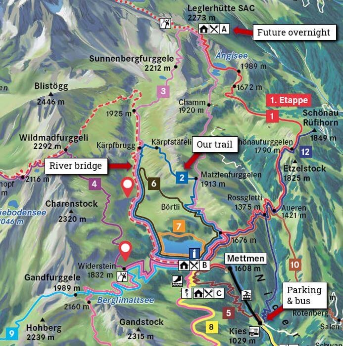
Mettmen is a reservoir at the edge of an alpine valley, high above the pretty village of Schwanden in the Glarus valley. (You may remember my snowy post-holing hike that ended in Schwanden, back in March.) To reach the trailhead, I caught a 6:43am train from Zürich HB, transferred to a bus that wound its way up a precipitous one-lane road to Kies, then transferred to a gondola that takes hikers to Mettmen. There were four other hikers in the gondola, and a young woman I later learned was on staff at the Leglerhütte – the alpine hut that was my destination for the day.

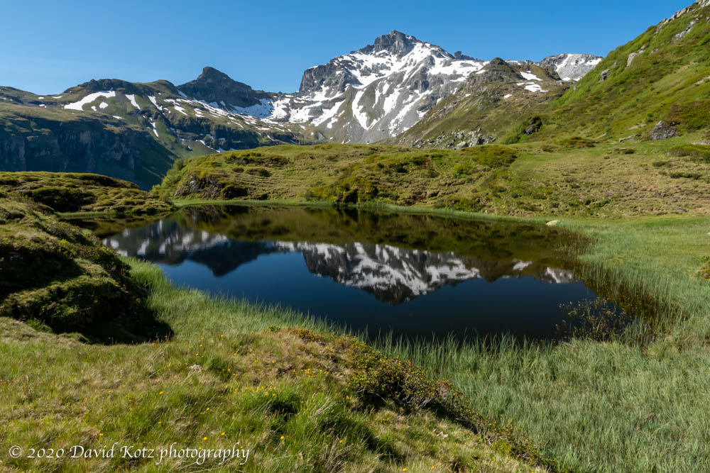
After the short gondola trip I quickly walked around the tourist hotel and across the dam of the reservoir to head steeply up the slopes of the right side of the valley. The sun was warm, even hot, and I was alone as I strode ever upward through alpine flowers. The sound of cowbells grew fainter as the rush of water cascading from the high snowfields filled the valley.

As I reached the upper end of the valley, I started seeing Chli Chärf – a jagged, minor peak in this range, and Unter Chärf – an even more minor bump on its shoulder. They looked unattainable from this perspective – but a couple hours later I would stand on that ridge and exult in the panoramic view.
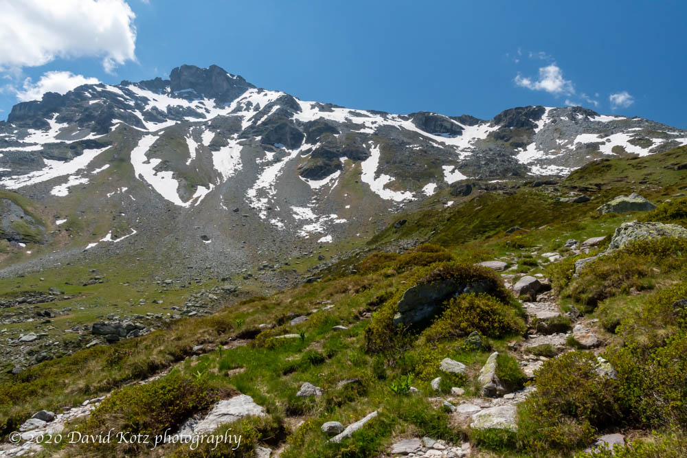
As I climbed to the edge of the valley, circling around the peak to the next watershed, I had to cross a few old snowfields. In the warm sunshine the snow was mushy, but with hundreds of footprints compressing the path since the huts reopened a month ago, the going was easy.

I rounded a bend and caught sight of Leglerhütte, an alpine hut run by the SAC (Swiss Alpine Club), with overnight lodging and meals for hungry hikers. At 2,721m (7,450′) this hut is not particularly high, but its view was nothing short of breathtaking. Wow.
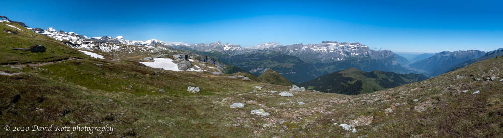
I stopped at the hut for a cup of tea – indeed, a cup of chai – and soaked in the view. The young woman from the gondola had beat me here, likely by an hour or more, and was now my waitress. The dozen other patrons sat on the sunny veranda, next to a pond made by a slowly melting snowfield; we all basked in the sunshine and enjoyed the lovely day.

I decided to make a go of it, and climb Unter Chärf – that bump on the ridge to Chli Chärf. On the map it looked doable. Sitting on the hut patio, staring up at its forbidding cliff, I was not so sure. The trail was marked blue (alpine/expert). As it turned out, the trail was strenuous, especially at this altitude, but not particularly difficult nor particularly far. By noon I was on its ‘summit’ and making a panoramic video (and another with voice annotation).

By 12:15 I was back at the hut; I debated heading back down, but hey – when you are at an amazing place, on amazing day, with no particular deadline to get home, why leave? I settled back into a table on the patio and ordered a ‘peasant sausage’ lunch – cold cured sausage and bread. It was tempting to order a beer – most of the other patrons had – but I had a long hike descent ahead of me.

While I was eating, the sound of a helicopter came closer… and louder… and was suddenly overhead. I had earlier noticed a stack of crates bundled with heavy ropes, and thought perhaps it was a delivery from earlier in the day. In fact, it was a set of material destined to be removed. The helicopter expertly swooped overhead and dropped a tow line right next to the crates, landing close to where I had hiked down from Unter Chärf minutes ago (video). Two crew members hopped out to take responsibility for hooking the load to the line.
As it turned out, they had dropped the line just a smidge too far from the crates, so the helicopter took off, the ground crew moved the tow line, and the helicopter landed on the other side of the hut. All the patrons watched as the bundle was hitched and the helicopter took off. I was standing on a stone wall and, at one point, the propwash caused me to lose balance and forced me to jump down. The entire operation took less than five minutes (video). Impressive!

I retraced my steps to the valley, but then took a different trail that dropped down into the valley and followed the stream back to the reservoir. It was a beautiful way to descend! I kept my eyes open for wildlife – this valley is a preserve and critters like steinbock (ibex) and gams are supposedly common. (No luck today.) At one point the stream disappears underground for a dozen meters, forming a natural ‘bridge’ across which the trail passed next.

I was back at the reservoir in time for the ideal return trip – the bus takes a 3-hour lunch break, and runs only once an hour anyway – so I was pleased to reach the gondola in time to take its first post-lunch journey. The top of the gondola is remotely operated from the base; the door and gate closed and locked, just as three prospective passengers approached. They looked rather sad! There must be a camera – the doors unlocked and they were allowed to board. Hooray for operator discretion! The gondola was thus late landing below – but the bus driver waited for all of us to board, and we were off. I was home by 4:30pm.
What a spectacular day! Be sure to visit the gallery – full-res photos and videos are there.
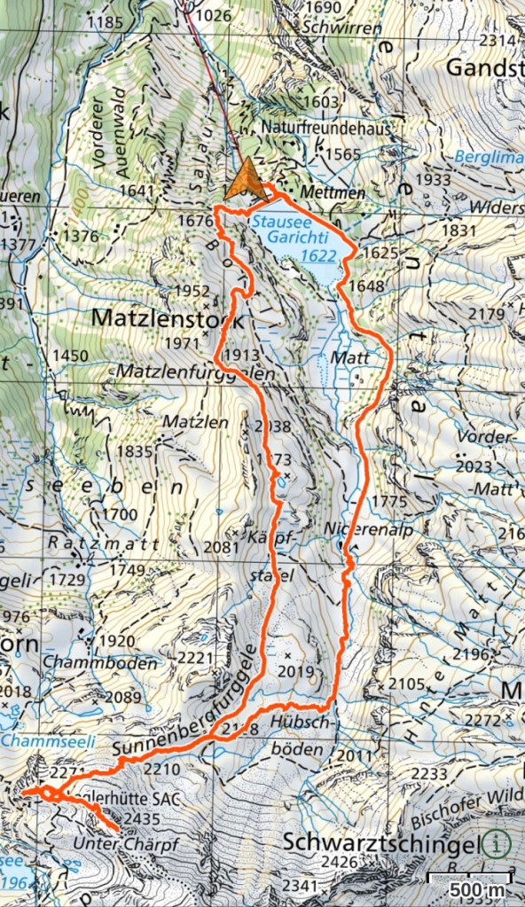
Hike stats: 13.68km, gain 886m, descent 886m, start at 1590m, high point at 2436m. Hike time 4h22, stop time 1h28. See maps below; the first is from a post from another blogger recommending route #2; I took route #3 and added a side trip to Unter Chärf. The second is my route as recorded.

Well, another WOW! Just plain WOW!
>