
I saw an unusually long sequence of sunny days ahead and leapt at the chance to snag the four peaks of the Seward Range, a rugged and remote section of the Adirondacks High Peaks. The result? Blood, sweat, and tears (pick two).

The four peaks in this range – Emmons, Donaldson, Seward, and Seymour, from south to north – are each over 4000′ elevation, and thus members of the 46 Adirondack high peaks. (At least they’re an honest 4000′, unlike my recent peaks Couchsachraga, Nye, and Cliff.) When I studied the map last year, I was struck by the remoteness of these peaks – compared the central high peaks region, they are completely trailless, and to reach even the base of these mountains are many miles from the trailhead. I imagined myself crashing through dense spruce forest with a compass and a hope that I’d not wander off into a trackless drainage. Not so.
As I’ve since learned, there are hundreds of other people out to bag their peaks and become a 46er. They leave “herd paths” – unofficial, unmarked, unmaintained trails from the marked trail to the summits. With heavy traffic, and some informal maintenance by a few kind souls, these paths are as easy to follow (often easier!) than the officially maintained trails. Thus I set out with confidence to nab Seymour on Friday and the other threesome on Saturday.

The approach to Seymour is an easy 5.5mi walk along a fairly level trail and dirt road, with the junction clearly marked by a stone cairn. Here, the climbing truly begins, following the brook in the steepest, most direct path to the summit. With heavy traffic, limited maintenance, thin soils, and a steep approach directly up the fall line, the path is severely eroded. Sad, in a way. I reached the main summit ridge and the trail leveled out. With all the rain we’ve had this summer, every flat section was a pit of mud, requiring a nimble dance to hop along the sides or firm spots to avoid wet feet. In one such spot, I was watching my feet, pushing through some overhanging fir. In my final hop I bounced directly into an blowdown, horizontal across the trail at about face height, slamming the top of my head into one of its stubby old branches. Knocked backward, I put my hands out to avoid landing smack in the mud. Saved from the mud, but realizing that my head was now bleeding, I shook off my backpack and fumbled through my pack for my bandana. Blood was dripping everywhere, on my pack, on my face, on the trail.

As a solo hiker, these are the kinds of situations one worries about. High on a remote peak, injured, and alone. As it turns out, I was likely the last person to ascend Seymour that day, although it was only 3pm. As I pressed the bandana into my scalp, I wondered about the severity of this cut and whether it would be wise to stay overnight and hit the rest of the range tomorrow as planned. Or, for that matter, to even complete the final hundred yards to the summit of Seymour. Fortunately, the bleeding stopped quickly, I wiped the blood off my glasses, and I was good to go.
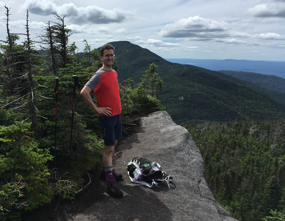
The summit of Seymour has limited views but there’s a wonderful side-trail to a viewpoint that allowed me to peek at what I had in store for tomorrow: Emmons, Donaldson, and Seward.
I scooted carefully back down the steep and slick herd path, and cruised back to my campsite, strategically placed at the junction between the approach to Seymour (from the north) and the approach to the other peaks (from the west). I was the only tent next to a pleasant little brook, so I bathed and washed off the blood, sweat, and mud of the day.

Saturday broke clear and I got an early start at 6:30, cruising south along the Calkins Brook Trail – really, an old road – making 4mi/hr to the junction. Again, a cairn marks the turn and a herd path follows Calkins Brook toward the summit ridge. Much gentler than the north side of Seward or Seymour, and following a pretty brook, this is a much more pleasant approach. I reached the ridge at a T junction; here I would have to go right out-and-back over Donaldson, Emmons, and Donaldson, and left out-and-back to nab Seward. I summited Donaldson by 8:40, feeling pleased at my speed so far and enjoying good views of the High Peaks. Continuing south along a rugged and muddy ridge to Emmons, I managed to roll my ankle. Hard. Dang, not another injury, just shy of a peak. I pressed on to Emmons by 9:30, and enjoyed a mega-dose of Ibuprofen with my gorp. Here I did a flip-turn and scrambled back over Donaldson and struggled up the rugged ridgeline to Seward. I now started to see some other hikers – two couples I’d passed coming up Calkins Brook, and the first of the many who would come from the north side of Seward. They confirmed that climb’s nasty reputation and I was pleased I’d chosen the western approach.

By 11am I was on the summit of Seward, #45 out of 46 for me. A great feeling, despite the lump on my head and the soreness in that left ankle. I flipped again, retracing my steps down the ridge from Seward, down Calkins Brook, and cruised back along the road/trail to my campsite. After a quick sponge bath in the brook, I packed up my camp and wearily packed out the 1.5mi to the trailhead, arriving by 3pm. Woof. Two long days, but I felt strong. Blood and sweat. No tears.
Check out the rest of the photos.
Friday: 13.3mi = 1.5mi backpack, 9.0 commute, 2.8 climb and descend.
Saturday: 13.8 mi = 1.5mi backpack, 3.6 commute, 8.7 climb and descend.

There’s a misconception and bad practice your trip report promulgates.
“They leave ‘herd paths’ – unofficial, unmarked, unmaintained trails from the marked trail to the summits. With heavy traffic, and some informal maintenance by a few kind souls, these paths are as easy to follow”
This is a misconception. The so-called “trailless” peaks haven’t been trailless for decades. They used to have true herd-paths, often multiple braided paths converging on the summit, but they were consolidated back in the 90’s into officially-accepted primary routes to a summit. Most are recognized as official trails that, by design, are left unmarked and only receive a modest amount of maintenance (only enough to prevent the establishment of new braided paths). The idea is to provide some semblance of an old-time herd-path (albeit with some maintenance). A long time ago, these trails were not depicted on maps but virtually all modern maps show them.
https://hiking.waymarkedtrails.org/#….1637!-74.1795
If you return in autumn or winter, you may discover “these paths are as easy to follow” isn’t necessarily accurate.
“every flat section was a pit of mud, requiring a nimble dance to hop along the sides or firm spots to avoid wet feet”
This is a bad practice. Please don’t do this because it contributes to the trail’s destruction. You are engaging in trail-widening which is a pervasive problem in the High Peaks. In fact, most trails look the way they do (broad muddy wallows with scoured sides) because hikers avoid walking through wet and/or muddy areas.
I’m closing in on my tenth round and can assure you that my hiking poles often find some kind of ‘stepping stones’ across the muck. Very often, there are stones, logs, branches, or firm spots within the mud (visible or just beneath the surface) that permit crossing it without much drama (aside from muddy footwear). Worst case, I use my poles to ‘pole-vault’ myself across the mud. In addition, it’s currently summer, a time when having wet footwear isn’t a significant liability.
Aspiring 46ers who damage trails (and engage in other destructive practices like carving symbols into trees) need to do some soul-searching. In their quest for a patch, they’re leaving a trail of destruction in their wake. Every wayward footstep adds to the cumulative damage. Since the completion of my first round in 2010, almost 3000 new 46ers have been registered, and I clearly notice the increased damage to trails, predominately due to trail-widening. All hikers (especially 46ers) should invest a little extra effort to protect the place they’ve come to appreciate.
Taras – thanks for your comments. I remember well the old days of braided herd paths, having hiked my first “trailless” 46er peaks in the 1980s. Today’s paths are certainly clearer, though far more damaged, than they were back then. I use poles in the way you describe, using rocks and logs wherever possible. Frankly, though, it is not always possible – in this wet summer, some of the mudpits were 18″ deep. I also know how difficult these trails can be to follow in winter – I struggled to find and follow the path to Couchsachraga in March this year. Unfortunately, most printed maps do not show these routes – for example, the latest National Geographic map shows only a few. Long-term, I expect the only solution is to reduce traffic (do people really need to “grid” the 46 or do multiple rounds?) or to construct well-designed, maintained trails (with lower inclines, waterbars, cribbing, puncheons, turnpikes, and other erosion-control features). I’ve built and maintained trails for over 30 years and know how important it is to design and maintain trails to avoid damage from heavy use.