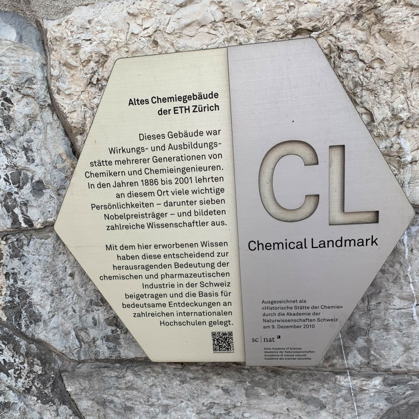
During our visit to Madeira we took two hikes along the Levadas – irrigation canals that follow the contours of the steep hillsides. See the photo gallery from our walk, and the post about the whole trip.
Levada dos Tornos is a newer levada (only 30-40 years old). It weaved through the forests and occasionally through a small village.
The hike starts at the end of one of the city bus lines, high above Funchal. A few steps above the bus stop you find the levada, flowing along past these houses.
This picture shows what most of the hiking is like on this levada. Flat, of course. Well, slighly downhill, as we were walking downstream. A pleasant dirt footpath follows the downhill side of the levada, which is about 2 feet wide and about a foot deep. This water irrigates fields along the way, and ultimately flows into an electrical generator serving Funchal.
The island terrain is very rugged, with steep hillsides and deep ravines. The levada follows the contours, of course, which means it weaves in and out of the ravines. In each little ravine, typically, is a small stream. Here the levada is built up a bit on a wall as it crosses the stream. Yep, almost always the levada is carefully engineered so that the stream either flows over, or under, but never into, the levada. Adding water to the levada would only make it overflow.
One of the neat things is that the levada is often integrated right into the architecture of the homes it passes. The levada path is a sidewalk used for daily traffic for many of the people living on its route; in some cases, the only access to the home (no road access).
This levada is quite luxurious. There are two “tea gardens” along the way. This one, the Jasmine tea garden, is run by a British couple. We stopped here for some tea and cakes. The menu had a hundred varieties of tea. It was a hot afternoon so I ordered iced tea. Unfortunately, they don’t do iced tea… I received a can of Lipton iced tea.
Shortly after our stop at the tea garden we passed through our first (and as it turned out, our longest) tunnel. The tunnel was just tall enough for me to stand, and just wide enough to leave a little path to walk. It was about 100 yards long, but took several minutes to get through because it was, of course, very dark and we had to move carefully (even with flashlights) to avoid bumping our head or slipping into the water. In the picture above, taken at the entrance, you can just barely see the light at the end of the tunnel.
Here Pam is nearly through…
At this point a large pipe joined the levada, and was supported by these crosspieces. Note the steep drop to the right of Pam… this section was a little bit hairy, especially since there were tiny springs above that meant little waterfalls fell on your head.
The scenery along the way was quite spectacular. Here we look out over ancient terraces, many still active farms.
The climax of this hike is an incredible, huge waterfall. The levada flows on a bridge crossing the stream, just upstream of where we see the waterfall emerge in this picture. Because it was getting late, and we’d missed the last bus at the next road crossing, we stopped here for a snack and turned around.
While we were snacking an old man came strolling by, in his traditional wool hat and turned-down leather boots, clearly comfortable with the hundred-foot drop along the levada. I’m pretty sure he was the levadeiro; he certainly looked the part. The levadeiro is a man who manages the levada, in particular, controlling the release of water into farmer’s fields. (We had passed many a little sluice gate where the water could be released to flow down into a farmer’s field.)
See the photo gallery from our walk, and the post about the whole trip.
This post was transferred from MobileMe to WordPress in 2020, with an effort to retain the content as close to the original as possible; I recognize that some comments may now seem dated or some links may now be broken.
We travel a lot with our kids. Every trip seems to require at least one layover in a large airport, requiring us to lug three kids, 1-3 car seats, a diaper bag, and a few other carry-on bags from one gate to another. Whew! that’s a lot to carry.
So I decided to convert the carseats into “back-packs”, so that I could carry the seats hands-free. I often stuff some of the smaller carry-on bags, coats, sweaters, etc, into one of the seats. It’s so much more comfortable than lugging them around in my arms!
One drawback is that you have to be really careful when you turn around, lest you bop somebody on the head with the carseat.
I ordered a simple set of back-pack straps from Campmor. I spent about $30 per seat and got some nice straps, but you could probably find nearly the same thing at any outdoor gear store, or probably places like KMart, probably for less money. You don’t need anything fancy: just a pair of straps, four sets of clevis pins with split rings, and probably a few washers. (The pins and rings attach the pack straps to the seat.) I was lucky to find holes in the seats in just the right places; I needed to add a few washers to strengthen the connection. I suppose it wouldn’t hurt to drill a hole, if necessary, but I can imagine a seat manufacturer claiming that voided the warranty.
The straps don’t interfere with the seat’s usage in the car, so I leave the straps on all the time, ready to go.
Disclaimer
Strength depends on shear strength of the pin.
I would never use this rig to carry my kid on my back. The parts of the seat to which I attach were not designed for that sort of stress, so the pins might pull right through. Also, as you can see in the photo, the system depends on the shear stress of the ring, unlike in most back-pack systems that depend on the shear stress of the pin. So I’d be afraid of the pin pulling through the plastic hole on the seat, or the ring shearing through, if there were a lot of weight. If I’m just carrying a diaper bag, and it fails, so what… but if I’m carrying a kid, and it fails, I’m in big trouble.
I doubt it would be good for long distances, unless you added some padding along the back.
It’s not really a back-pack in the sense that I can carry big loads. I guess it’s a car seat you can carry on your back.
This post was transferred from MobileMe to WordPress in 2020, with an effort to retain the content as close to the original as possible; I recognize that some comments may now seem dated or some links may now be broken.
We climbed Moosilauke on New Year’s day, once again.
A group of us climbed Mt. Moosilauke on January 1, 2000. We were some of the last to summit on this otherwise busy day on the summit.
Nearing the summit of Moosilauke on New Year’s Day, 2000.
Although the traditional chubber alum group did not hole up in a Y2K-compliant cabin for New Year’s eve, opting instead for the house of Ken and Karen Kaliski in the sprawling metropolis of East Thetford, we still headed out on New Year’s morning for a hike up Moosilauke.
While there was some discussion of summiting at Midnight, or even at dawn, most groups seemed to get a later start than that ;-). Our group (David Metsky ’85 and Brenda Conaway, Ken Kaliski ’85, Ed Lowney ’85, Kathy Gelhar ’87, myself ’86, and two friends Andrew and Ching) got a crack-o-dawn start at 10am, at the base of the Carriage Road. There was maybe 2″ of snow at the base, high clouds, and temps in the 20s predicted.
Boy, that Carriage road is a long slog, when on foot rather than on skis. We were especially gratified, then, when we reached the viewpoint near the turnaround. Just then, the clouds cleared and the sun came out, illuminating the brilliant white Moosilauke and Washington. At about 2pm we were in the middle of the ridge crossing over toward the north peak when we met David Hooke ’84 and Kathy Roy ’85 coming down. David told us of the crowds on the summit, larger than ever seen on New Year’s Day. Many chubbers were sighted, including Put Blodgett ’53 hiking with Sam Adams (son of Sherm Adams ’20) and Jim Hardigg ’44 (!).
While we were chatting, down came Jack Noon ’68 and Bob Averill ’72. On the summit Jack had been signing copies of his new book “Up Moosilauke”, and proceeded to hand out copies.
While we were skimming the books, who should appear behind us but Bernie ’74 and Mary Waugh….
On the way up we had met Dick Birnie ’66 coming down, as well as a backpacker who said he had spent the night on South Peak because “the North Peak was too crowded with other people.”
The summit itself was as windy and icy as ever, although warm (20 degrees or so) and given the late hour we turned around and headed down fast, racing the darkness. No luck. We walked out by starlight to the howl of distant coyotes, satisfied with a great hike and a wonderful way to welcome the new century.
This post was transferred from MobileMe to WordPress in 2020, with an effort to retain the content as close to the original as possible; I recognize that some comments may now seem dated or some links may now be broken.
A group of friends have gathered at a Dartmouth Outing Club cabin every New Years for since the mid-80’s, when we were undergraduates. This years incarnation took place at John Rand Cabin, near the Moosilauke Ravine Lodge on the east side of Mt Moosilauke. There was a group of 10 of us at the cabin for a thrilling evening of entertainment before going to sleep just after midnight.
The next day we planned a hike up the mountain, via the Gorge Brook trail. The group consisted of Dave M (your scribe), Dave and Kathy Hooke, Dave Kotz, Brenda, Ed, and Ken. We got a late start because we had to pack up the cabin and get all our gear down to MRL, so we didn’t get on the trail until 11:00AM. There were helicopters flying overhead looking for a missing Lear Jet that had disappeared on Christmas Eve.
The lower part of the hike went uneventfully, and we stopped at Last Water, where I told Brenda to leave one of her ski poles because we were coming back down this way. Turns out we didn’t, so if anyone finds a 135CM ski pole at Last Water, contact me. There was a real hard pack of snow on the ground, no need for snowshoes or crampons. Our gear consisted of Sorel pak boots, leather hiking boots, and plastic mountaineering boots. It was cold (2F at the summit) but little wind and good visibility most of the day.
We got to the first views, on the logging road section of the trail where we did a layer break and drank water. Then we pressed on to the second set of views where we took a longer break. There we had some food and water, and geared up a bit more. Then we pushed on to the summit.
Just before treeline we ducked into the woods to put on our final layers. Then we headed out for the summit. It was pretty calm in the wind shadow of the summit and not bad on the summit itself. Here are pictures of people on the summit:
After a pleasant stay on the summit, we started down the Carriage Road, headed for the Snapper trail back to Gorge Brook and the Lodge. We met a few people headed to the summit via Glencliff, but none headed down Gorge from the summit. This meant that Brenda’s ski pole would remain at Last Water. We stopped at the Glencliff junction to de-layer and rest. Then it was down the Carriage Road, too icy for skiing, past the Moosilauke Permitted Use sign and down to our final stop at the junction of Snapper and Gorge Brook. The icy formations in Gorge Brook kept us occupied in our tired state. Then a final uphill section before reaching the Ravine Lodge. We gathered out collected stuff and hiked/skied out to the cars on Rt 118.
Pictures for this report were provided by Brenda Conaway, Dave Kotz, and Dave Metsky.
This post was transferred from MobileMe to WordPress in 2020, with an effort to retain the content as close to the original as possible; I recognize that some comments may now seem dated or some links may now be broken.
Nordic skiing near the town of Saint Cergue, Switzerland.
On December 8, 1998 I was near Geneva on some business, and passing through the town where Alex de Sherbinin ’84 lives and works these days, so I stopped in for a brief visit. Just hours after landing, complete with jet lag, he picked me up at the Nyon train station and whisked me up into the hills. Geneva and Nyon are low altitude, along Lac Leman, but the land rises rapidly up to a ridge known as the Jura, perhaps 3000 feet elevation. As we drove up a windy road, the snow became deeper, and the views more spectacular, back across the lake to the Alps and Mont Blanc. We stopped in the little town of Saint Cergue for a little picnic lunch and to wait for the shopkeeper to reopen so I could rent some XC skis. When she finally returned, the neighboring shopkeeper scolded her, in reference to us, “These are the seventh people to come into my shop to ask when you will reopen, won’t you please put up a sign saying when you plan to return.” Even in my limited French I caught the gist of her resultant muttering about how she has the right to close when she wants, if she wants to close, she closes, etc etc etc.
A few francs later and we were off to ski on an amazing network of set tracks, in gorgeous conditions. It was a beautiful sunny day, temps just a little below freezing, and fresh snow. The trails rolled over gentle hills, in and out of the woods. The bright sunshine and the exercise pretty well eliminated my jet lag. There were few others out that day, being midweek, and most who were out were retirees about twice our age. I can only hope to be that active at that age.
Alex later took me by his office at the World Conservation Union (IUCN), across the street from his apartment where it seemed every window had a view onto the Alps, and around the corner from the WWF international headquarters. At the IUCN everyone seemed to be working on momentous projects in faraway places. Really neat place.
Thanks Alex!
This post was transferred from MobileMe to WordPress in 2020, with an effort to retain the content as close to the original as possible; I recognize that some comments may now seem dated or some links may now be broken.
Wow. My wife Pam and I just returned from a spectacular two-week safari in the national parks of Tanzania, east Africa. It was a “family safari” with six other family (and friends of the family), organized through Thomson Safaris. Thomson is just one of many companies operating safaris in Tanzania, which is a booming industry now that the safari market in neighboring Kenya has pretty well saturated, and people are discovering Tanzania to be a safer, cheaper alternative.
We flew through Amsterdam, which gave us the opportunity for a 1-night stopover and a long jet-lagged day touring the museums and canals of that beautiful city. Probably the most important feature of the stopover was cleaning out the duty-free shops in Shipol airport, buying enough bottles of wine so our group had one for each night on safari.
The flight from there to Arusha, Tanzania is even longer, about 9 hours to span endless miles of the deserts of north-central Africa. It really gives you a sense of just how huge Africa really is when you fly for hours across so much “empty” space.
Kilimanjaro International Airport in Arusha is a small one-gate sort of place, primarily serving safari tourists, and diplomats attending the U.N.’s Rwandan war-crime tribunals being held in Arusha. The town of Arusha, with about 200,000 people, is closer to the major national parks, including Mt. Kilimanjaro just a few miles to the northeast, than is the coastal capital city of Dar es Salaam.
Both English and Swahili are official languages, although with a population from 120 different tribes there are another 120 other languages that can be heard around the country. Our guides were thus trilingual, speaking English, Swahili and their tribal language.
For our group of eight, Thomson supplied two guides and one guide-in-training, and two specially modified LandRovers. The guides, John and Gebra, are all native Tanzanians and had been guiding for 10-15 years, so they knew an incredible amount about the parks and wildlife. Indeed, Gebra was somewhat of a birding specialist, and could not only identify a passing bird by name, but could also instantly tell you the page and plate number where its picture could be found in the bird book. Our guides were clearly more experienced than many of the other guides we encountered; often they would stop to talk with our guides along the road. There seemed to be a friendly fraternity among the guides of various companies, and they all seemed to cooperate to give each other tips about the location of the best wildlife.
We spent the first day in Arusha national park, a relatively small park near Arusha and on the slopes of Mt. Meru. Like Kilimanjaro (at 19000+ feet the tallest in Africa), Meru is a tall volcano with a lush tropical rainforest on its lower slopes. Here we established the basic daily pattern: slowly driving along very bumpy dirt roads, watching for wildlife and stopping whenever there was something interesting to watch. The roof the LandRover popped up so that we could stand and look in all directions, yet still be shaded from the equatorial sunshine. Unfortunately, it was cloudy and misty that day, so we had no views of Mt. Kilimanjaro.
Almost inches after crossing the park boundary, where the banana and coffee plantations gave way to the rainforest, we came across a set of giraffes next to the road. A little further along a troop of baboons were lolling about in the road in front of us. Ponds were filled with thousands of flamingoes, and visited by herds of cape buffalo, waterbuck, and the tiny dik-dik antelope. What amazed me is that most of these animals barely noticed our presence, even when we pulled up only a few yards away from them. In general, most of the animals in the parks have no reason to fear humans, particularly humans in LandRovers.
We hired a park ranger to join us for a hike along one of the forest roads. He carried a rifle and was a required part of any hiking party in the park. Apparently, cape buffalo (when alone) are easily startled and can become quite dangerous. One look at their horns convinced me that I did not really want to test that hypothesis. Although we did startle a pair of buffalo on the walk (and the ranger’s rifle was rapidly in position for action) they ran off into the woods, so the real excitement was spotting a bunch of black and white colobus monkeys high in the trees.
The next day we spent in Tarangire National Park, which is further to the west and is a completely different experience. Set in rolling savannah country, this dry and sparsely vegetated area is teeming with elephants. Well, let’s just say that we saw over 100 elephants in our first 3 hours. Many had (very cute) little baby elephants along with them, and many were right next to the road. One teenage male was quite blustered by our presence, flapping his ears and trumpeting, and making small false charges. Unfortunately, the elephants love to eat Baobob trees, to the point that the baobobs are likely to disappear from the park.
While some of our group saw lions there, indeed, a mating lion couple, the real lion action would come later in the Serengeti.
From Tarangire to Serengeti is a long long poke over some unbelievably bumpy and dusty dirt roads. The worst roads of New Hampshire were smooth super highways compared to some of these roads. We broke up the trip with an overnight at a lodge perched on the edge of the great Rift, overlooking a huge valley with Lake Manyara and its flocks of flamingoes, and in the distance, our only view of Mt. Kilimanjaro. This was an agricultural area, and we stopped in the market in the bustling village of Mto Wa Mbu, where there were piles of bananas, rice, beans, spices, mangoes, and so forth. And a section for tourists with lots of crafts, mostly wood carvings of ebony and rosewood. Bartering was the rule here, and I managed to get a very nice carving in trade for a pair of old sneakers, a water bottle, and some cash. The hot commodity appeared to be socks (yes, socks), and anything with Michael Jordan, particularly sports magazines.
We spent three days in Serengeti National Park, a huge seemingly endless plain of grass that stretches for hundreds of miles, connecting to game reserves and to some parks in Kenya. Huge herds of animals roam these plains, following the rains. Although the largest herds had already migrated north (the rains ended in May), we nonetheless were often surrounded (quite literally) by hundreds of zebra, wildebeest, gazelle, topi, and others. Giraffes could be found wherever there was a clump of acacia trees, and hippos and crocodiles hung out in the pools along the river. We found troops of hyena, including one with babies, as well as jackals and foxes. But the most amazing were the lions and cheetah. We could pull right up next to snoozing lions, only 20 yards away. The cubs would tussle and play, and the adults would keep right on snoozing. We were very lucky with the one cheetah we saw, who we found in her den with 5 cubs. When we were the only folks there, she came out to look around and the cubs played in the grass.
Unfortunately, later, there were other tour operators who insisted on driving within about 3 feet of the cheetah in her den, way too close; our drivers reported those drivers to the park rangers. Apparently the parks have severe penalties for driving off road where not permitted, or for disturbing the wildlife. In Tarangire, a driver can be banned from the park for one year, which effectively puts them out of the business.
Early one morning, before dawn, we drove out for a pre-breakfast peek at the wildlife. Right outside of camp, only 100 yards from our tents, we spotted a lioness as she sprang after a herd of wildebeest. She chased them for a while, to no avail. Nearby a pack of hyenas waited patiently.
Perhaps one of the most striking things about the Serengeti, with its endless plains, roamed by herds of 1.8 million wildebeest and zebra, is that I could see what the North American west used to be like only 150 years ago. It’s sad what we have lost, and impressive what they have managed to protect.
After the Serengeti it seemed that it could not get any better. But then we moved on to Ngorongoro crater, the largest perfect caldera in the world that is habitable. Long ago it was a huge volcano, taller than Kilimanjaro. The lava that filled the core of the volcano drained away, leaving a hollow shell that collapsed to form a caldera, i.e., a crater. [My apologies to the geologists in the crowd, who I am sure see right through my simplistic understanding.] The thousand-foot high rim around the crater is 12 miles in diameter, and is high enough that it catches clouds and thus receives rain all year. Thus there is a rainforest on the rim, and the streams flow down into the relatively dry crater to form a shallow lake. With no outlet, the water evaporates to leave a highly alkaline environment. This shallow, alkaline lake is prime territory for thousands of pink flamingoes. The sight of that much pink feather and blue water is stunning, as is the smell of droppings from thousands of flamingoes (whew!).
Over 22,000 large mammals live in the crater; huge herds of resident zebra, wildebeest, gazelle, etc. These make easy targets for a fat and happy population of lions and hyenas. We spent an hour one day watching a lioness, barely crouched behind a tiny hillock, tense and waiting to spring as unsuspecting wildebeest strolled by. Neither the wildebeest nor the lioness seemed to notice that we were only about 25 yards away the whole time. Several times we were *sure* that she would spring out to catch a wildebeest that was only about 15 yards from her, but she decided to wait. Apparently she was waiting for a particularly stupid wildebeest (and they are pretty stupid) to stumble right over her. Ultimately we tired of watching before the lioness tired of waiting for her lunch; we later heard that she never did chase anything that day.
The confined space makes for wonderful wildlife viewing, but it also means that there is a very high density of LandRovers. At one stop we counted 14 LandRovers stopped to watch a rhino family. The black rhino are dwindling in number– only 22 left– despite intense protection from poaching. The Japanese market for rhino horn means that poachers can make a lot of money for killing one rhino, leaving it to rot while they take only the horn.
We took a side trip here to hike up to the rim of neighboring Olmoti crater. The 10,000′ altitude plus two weeks of sitting on our butts in a LandRover made this climb somewhat strenuous, though short. From the rim we could look over another beautiful crater, this one filled with cows. Here we met a young mother of three; she was just one of several wives of her husband, who apparently owned many cows and thus could afford several wives and many children. They carry their children on their backs, wrapped in the long blankets they all wear.
Yes, this is Maasai country, and the area is managed as a conservation area in which the Maasai tribe is allowed to live and graze their cows as they have done for centuries. Indeed, the Maasai have done an amazing job of maintaining their traditional culture and living style, in small villages of round stick-and-dung huts, living off their cows. They are a tall, proud people with very colorful dress: men wear a red blanket, somewhat like a toga, and carry a wooden staff and a spear, women wear gorgeous silver and bead jewelry.
We stopped by one village, where (for a price) they let us look around, visit their homes, and take pictures. They offered some of their crafts for sale, particularly the gorgeous beadwork of the women and the carved staffs and spears of the men. I don’t want to romanticize it– the area between the huts was strewn with cow manure, there were flies everywhere, and the huts were filled with smoke. They have a hard life, and I am really impressed that they have managed to maintain the traditional lifestyle despite the modernization of the rest of their country.
So Tanzania is a fascinating and diverse country, with many kinds of people and many lifestyles. There is a lot of poverty, which is particularly obvious in contrast with the tourists and their fancy hotels, Gore-tex rainwear, and video cameras. It made me very thankful for the things that I have.
We had three types of accomodations: fancy lodges, tented lodges, and tented camp. They all had spectacular locations, such as the lodge on the rim of Ngorongoro crater. Tented lodges were permanent installations where each “room” was an independent canvas tent, albeit with a concrete floor and shower/toilet attachment. The tented camp was a temporary setup run by Thomson folks, although none of us have ever camped in such luxury. Each couple had their own large canvas tent, with attached toilet tent; little shower tents; a dining tent; beer and wine on hand; great food; campfire made for you; warm water and a basin prepared for you at bedtime and at wake-up time. They even baked and decorated a birthday cake for me on my birthday.
Overall I found the Tanzanians to be a very friendly people, and the country to be absolutely gorgeous place. Definitely worth a visit if you ever have a chance. Although excessive tourism often ruins many places, the country seems (for now anyway) to have a fairly good conservationist attitude, as did our tour company. One quarter of Tanzania is already set aside in parks and game reserves. Thus it seems likely that the wildlife, scenery, and culture will survive reasonably well.
Sorry I did not include many photos here. I scanned the best of the prints, but most of the really good pictures are on slides. The photographic opportunities were phenomenal, given the amount and proximity of wildlife, and stunning scenery.
P.S. Our son John, 9 months old at the time, spent one week with his grandparents and another week with his cousins, and by all accounts had a blast without mom and dad around. Mom and dad missed him, on the other hand, quite a bit. At one refueling stop we met a local woman and her baby; Pam was so taken with her baby that she pulled out a photo of John to show her. In this picture of her you can just see her holding John’s photo, which she kept.
This post was transferred from MobileMe to WordPress in 2020, with an effort to retain the content as close to the original as possible; I recognize that some comments may now seem dated or some links may now be broken.
We skiied into the deep, deep blue sky over the summit of Moosilauke on Sunday morning. We had just skiied up the Carriage Road and across the summit ridge to the summit, in the snowiest conditions any of us could remember. The entire east slope of the summit cone was a smooth snowfield, and there was 4-6′ of snow on trail across the ridge. Although some clouds danced around the summits of the other major Whites summits, Moosilauke and Washington shone clear and white in the deep blue sky.
David Kotz and the summit of Moosilauke, from Carriage Road.
The weather was very warm, about 20-25 degrees, although there was a very strong west wind that made the ridge-crossing bitter cold. Out of the wind and in the sun, sitting on the slope east of the summit, though, we enjoyed a comfortable early lunch. Early because we had made it to the summit by 11am, after a 7am (yawn) start encouraged by Dan Nelson.
Although snowmachines we passed on the way down had packed the trail into a slick gully, the snow was deep and fluffy, which was good considering how fast we were going when we flew off the trail and into the trees. Despite our best efforts at snowplow and tele turns, we all took some spectacular face plants.
The crew consisted of Dave Hooke, Ed Lowney, myself, Dan Nelson and his friends Leo and York, a young DOC chubber named Bart, and two excited dogs. The “Best Shades” award goes to Ed and Dave Hooke. What a blast. Thanks for pushing us to get up early, Dan.
This post was transferred from MobileMe to WordPress in 2020, with an effort to retain the content as close to the original as possible; I recognize that some comments may now seem dated or some links may now be broken.
On August 24, 1996, I finally finished hiking all 48 of the peaks over 4000′ in the Whites, on Wildcat A.
This post was transferred from MobileMe to WordPress in 2020, with an effort to retain the content as close to the original as possible; I recognize that some comments may now seem dated or some links may now be broken.
With my friends David Hooke, David Metsky, and Ed Lowney, we skied up and down Moosilauke.
One day in March, a bunch of us Daves and one Ed decided to ski Moosilauke, since the snow was supposed to be good and we hadn’t skied the mountain since December. So, we parked just off 118 at the Access Road and skied up to the Moosilauke Ravine Lodge, where we put on skins. We chose to ski up the Gorge Brook trail, since it’s a more challanging route than the new Snapper trail.
Down low, the conditions were perfect, with nice sunshine on fresh snow. We crossed Gorge Brook and started climbing for real. At the upper views, the clouds were coming in, but we could still see the Blue Ridge poking through.
Above there, the trail is much more exposed, here crossing the Balcony. The first views of the summit ended our hopes of getting any views, but that wasn’t about to stop us. At treeline, we removed our skis and pushed on into the 40 MPH winds after gearing up.
The summit was windy, cold, and wonderful. We took a few summit shots (#1,#2), looked around and headed back to our skis for the descent. We were warming ourselves up on the upper stretches, occasionally stopping for views of the ridge before starting the fast and furious descent. The snow was excellent, and for me I finally had a skill level that was up to the task. We made it back down in about 1/5th the time it took to make it up and we only kissed a few trees.
– by David Metsky
This post was transferred from MobileMe to WordPress in 2020, with an effort to retain the content as close to the original as possible; I recognize that some comments may now seem dated or some links may now be broken. – David Kotz
The trip to the hut is pretty straightforward, just up the Crawford Path and take a right onto the Mizpah cut-off, total distance is only about 3 miles. People had hiked in front of us, but in places the light snow had drifted in and completely covered the tracks.
When we got to the closed hut the weather seemed to be turning worse. The snow was falling heavier as we stopped for lunch. There were lots of folks tenting near the hut (much too close, actually) and one group set up their tents under a huge huge cornice on the far end of the hut. I hope they made it through the night.
This post was transferred from MobileMe to WordPress in 2020, with an effort to retain the content as close to the original as possible; I recognize that some comments may now seem dated or some links may now be broken.