
In which we explore three beautiful slot canyons with waterfalls, learn how to make a “butt dam”, break Pam’s toe, survive Lava Falls, and fly by helicopter and plane back to our starting point. [Photos]
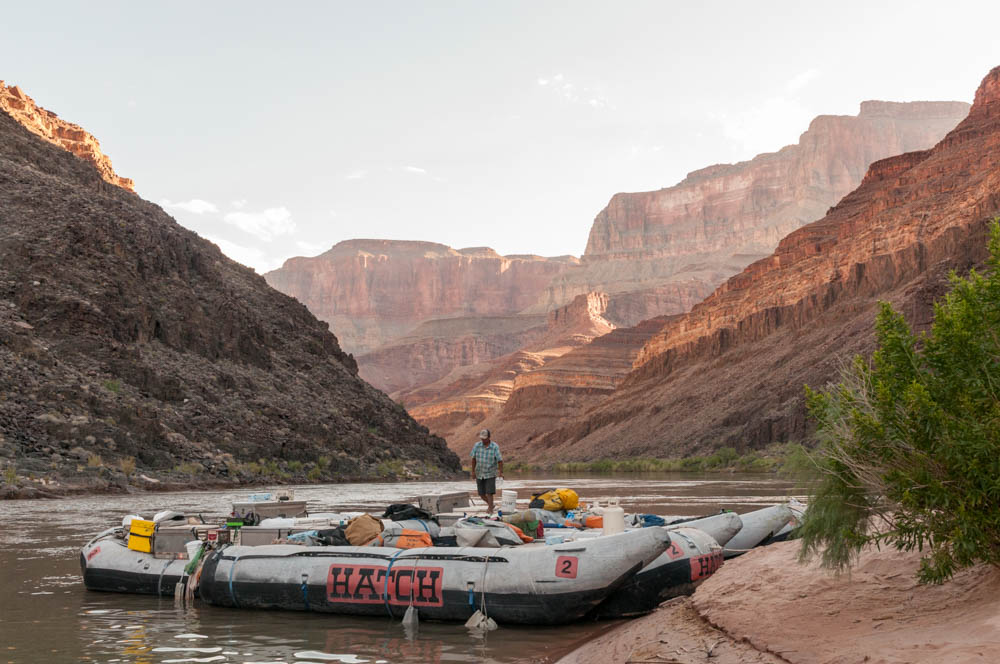
I awoke early on the fifth morning of our trip, still tingling from the scorpion’s neurotoxin. The dawn’s first light struck the rimrock high above as the crew prepared another fabulous breakfast and the passengers sipped their morning brew. After loading the boats, one task remained. JP removed the strap that held a small cooler tightly shut all night, then gingerly opened the cooler at the edge of camp. A four-foot Grand Canyon Rattlesnake, slightly dazed but glad to be free, slithered off to find its breakfast. Everyone but the snake was glad he’d spent the night locked in the cooler.

An hour down the river we pulled ashore to visit Deer Creek Falls (mile 136), possibly one of the most spectacular waterfalls along the river. Over 100′ high, the waterfall and its mist nurture a miniature garden close to the river’s edge. We had our sights set higher, and followed a trail’s switchbacks up the cliffside to reach the stream above the falls, where it winds through a slot canyon so narrow the trail actually hugs a ledge about 20′ above the stream. Soon, after a route not suitable for acrophobes, we reached a wider area of the canyon where the stream bubbled along beneath a few trees. At this oasis most of the group settled in for a rest, but a hardy group of explorers continued upstream.
A half mile later we reached the face of a cliff, where Dutton Spring erupts from mid-cliff in hanging garden to form a beautiful free-fall cascade. I snapped photos while Andy explored and Travis read another inspirational essay to the group. We filled our bottles with this cool spring water and headed back. Just as I was realizing that my body finally felt free of the scorpion’s toxic effects, 20 hours after the sting, I learned Pam had slipped and broken her middle toe. Nothing dramatic, but it sadly meant the end of Pam’s hiking for the remainder of our southwestern trip.

After lunch we stopped again at Matkatamiba Canyon (mile 148), a narrow slot canyon with a tiny stream. It was fun to use some old bouldering techniques to wiggle my way up the narrow canyon, hands on one wall and feet on the other. At the top, where the canyon widened to a broad ledge, Travis and Andy led the group by sitting in the middle of the narrow stream, damming its flow. Quickly the stream flowed around them, so others sat down to widen the “butt dam” until we’d nearly stopped the flow. On a count of three, we all stood to release a miniature flash flood into the slot canyon below. 😉 In the photo at left you can see us climbing back down through the slot canyon after leaving our “butt dam” behind.
Camp 5 was on a narrow beach alongside the rushing waters of Upset Rapid. After a dinner of pork chops and chocolate cake made in celebration of my 50th birthday, we spent our last night under the stars.
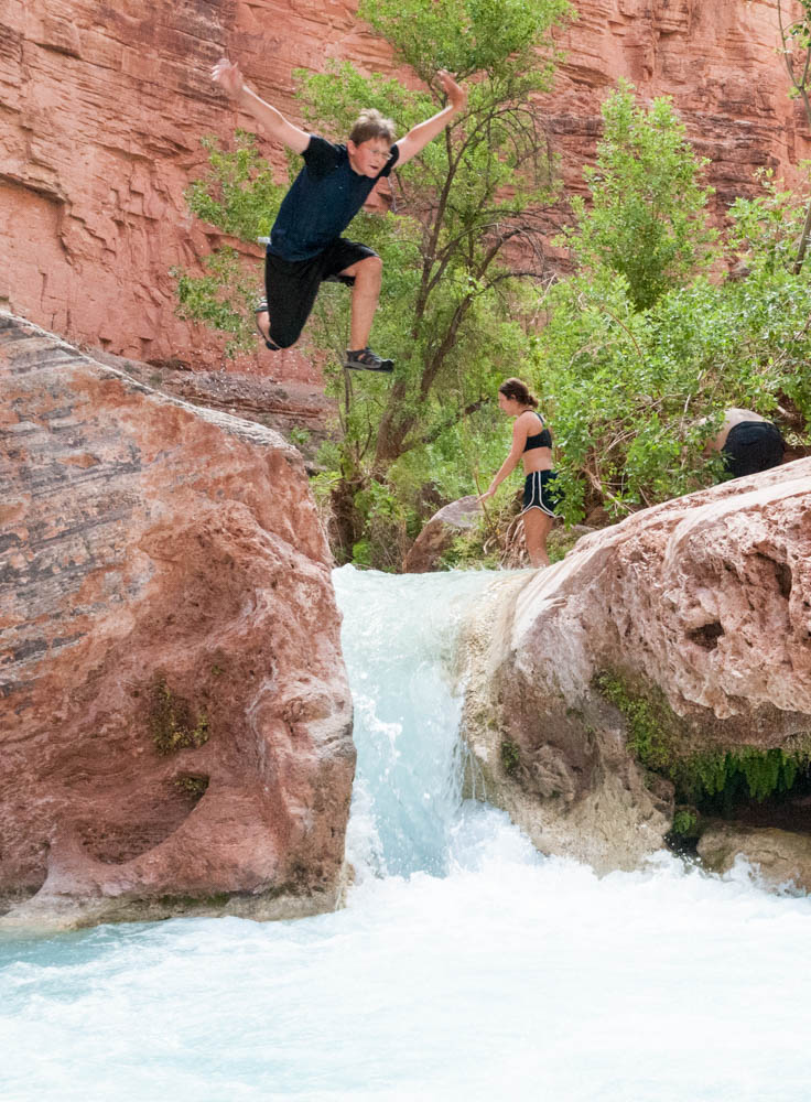
On Day 6 we hiked up Havasu Creek (mile 157) – which drains the lands of the Havasupai Indian Reservation – for a swim in its turquoise waters. Like the Little Colorado, its waters are milky blue because of the calcium carbonate that leeches out of the limestone far upstream. A beautiful setting, we found a pool at the base of a small waterfall where we could swim. One could easily climb atop a boulder and jump into the pool. As I crossed the stream above the waterfall to reach the boulder, I noticed the stream’s strong current pulling my ankles toward the fall, and moved upstream to avoid it. After my jump I was standing in the pool near the base of the falls, I caught a glimpse of one, then another, person slip over the falls and disappear. A few seconds went by and I realized they were not coming up! As I considered, one or two more seconds, whether to approach the falls and attempt a rescue, Travis came by in a flash and dove into the falls. Paige popped up, gasping, then Travis – he was told there was still someone in the fall so he dove back in. Joe popped out and then Travis. The whole frightening incident lasted less than a minute. Paige and Joe had been trapped by the force of the water in an invisible and surprisingly deep pit under the waterfall; all three of them spoke of the disorientation and attempts to push each other out and to find a handhold so they could pull themselves out. Counting our lucky stars, the group decided it’d had enough swimming for the day.
No more swimming, perhaps, but we still had plenty of opportunity to get wet. The biggest rapids of all, Lava Falls (mile 179), was formed many millennia ago when a massive volcanic eruption filled the canyon with enough lava to dam the river. Over time, the river punched through, but the remnants of that flow left a huge and violent rapid. We held on tightly as the boat bucked and through the rapid, huge standing waves crashing over the boat. Click on the following 43sec video to see Lava Falls from the center of the action – Andy’s lifejacket. [It should open in a new tab or window.] The waves are much bigger in person! Travis had so much fun he motored back up through an eddy and took us through twice more.


Rain started as we set up Camp 6, our last camp, next to the helipad (mile 188). Not merely a passing shower, we set up tents for the first and only time. In the warm rain, the group’s spirits were high – it was July 4th, and John and others led us in the singing of the Star Spangled Banner. After a lovely spaghetti dinner, we held a talent show. In the dark. In the rain. Now that’s a group in high spirits!
Gosh. If I have any talents they are not in the performing arts! Fortunately, I remembered the words to the one song appropriate for a group sitting in raincoats and holding flashlights to illuminate each performer: Ode to Gore-Tex, by David Metsky and Jeff Garneau.
The morning broke to a clear blue sky, fortunately, as the first helicopter thwop-thwopped into view and landed at 7am. The pilot stayed onboard as two men stepped out; one was the assistant who organized groups of five people by weight, but the other had a quick word with our leader, JP. A few moments later JP was back with his bags and assigned to the first copter out; sadly, he’d just received news that his mother died during the trip. Hatch sent the other fellow, a boatman, to take over JP’s boat so that JP could quickly join his family.
We quickly took family photos (see below) and group photos, and in turns the group boarded the helicopter for the short flight up and over the rim – Mara got to ride in front! We landed at the Bar-10 Ranch, which clearly does a good business as a stopover point for rafting passengers on their way out of the canyon. There we boarded a small plane (the ranch has an airstrip!) to take us back to the head of the canyon. Gorgeous views all the way back.
We spent the afternoon at Marble Canyon, a tiny outpost near Lee’s Ferry, doing laundry and preparing the car for the six-hour drive past Four Corners and on to Mesa Verde in Colorado to begin the second week of our southwest exploration. I’ll report on that leg soon.
All of us were sad to leave the Grand Canyon, a place of spectacular beauty and humbling scale and scope. We had traveled 188 river miles, but the river and canyon continue on to Mile 279, where the boats are removed at Pearce’s Ferry and the river slows as it forms Lake Meade. As we traveled, every bend in the river led to a different perspective on the place; every day led us down further into the Earth’s distant past. Floating by rock that is 1.7 billion years old, through a canyon that took hundreds of millions of years to form, puts everything into perspective. I’m glad I returned after 20 years, and so happy to have shared it with Pam and the kids.
Check out the slideshow for some of my favorite photos.
Day 5: Below Bedrock (mile 131) to Upset Rapid (mile 150)
Day 6: Upset Rapid (mile 150) to Helipad (mile 188)
Day 7: helicopter to Bar10 Ranch; flight back to starting point.

