
Can you see Mount Everest in the photo below? Neither can I. We spent six days trekking along the Singalila ridge, the border between India and Nepal, but we were in the clouds the whole time. Nonetheless, it was a fantastic trip and a beautiful place. Read on, and check out the photo gallery!
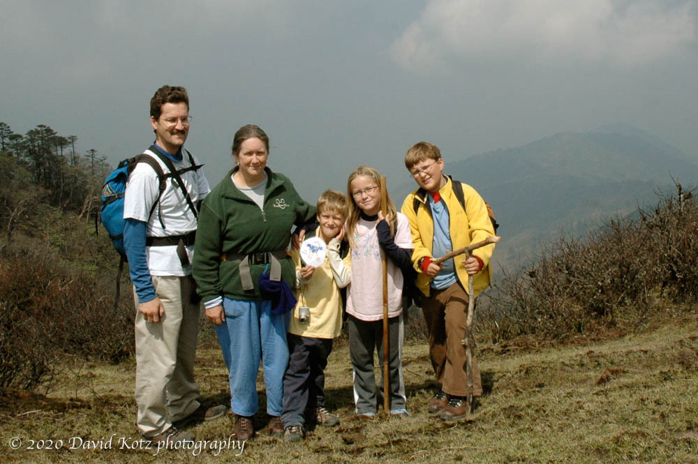
It has long been one of my dreams to visit the Himalaya. On Easter Sunday we set out for a 6-day, 6-night family trek in the foothills of the Indian Himalaya, after a day of acclimatization in Darjeeling (read previous entry). The Singalila ridge [location] is a popular spot for both domestic and foreign tourists, because of its accessibility and because it offers stunning views of both Mount Everest to the northwest and Mount Kangchenjunga (third highest in the world) to the northeast.
The best time to visit is just before (April-May) or just after (October-November) the monsoons. Fall promises clearer skies; spring promises slightly warmer temperatures. The kids’ 10-day Easter break seemed like a perfect time to go, and we found a chubber-recommended trekking outfit. In support of our family of five, the company sent ten staff (a guide, six porters and camp staff, three horsemen), four horses, and four dzos (a dzo is a cross between a yak and a cow). We stayed in tents (3 nights) or lodges (3 nights). This is truly first-class camping.

The Singalila ridge is a long north-south ridge that forms the border between India and Nepal on the western side of Sikkim (state) and the Darjeeling district of West Bengal (state). Our route takes us from the village of Dodhrey at 2590m (8,500’) up to the ridgeline, then weaving in and out of Nepal as the trail wobbles north along the ridge. Just before we reach the Sikkim border, our route drops off the ridge, down through the forests of India’s Singalila National Park, and into the Ramman and Siri Kholla river valleys with their terraced villages. We reach the ridge’s high point at our third campsite, a tiny tourist outpost of Sandakphu (3636m, 11,929’) [location]. Although the clouds never parted for us, I found some beautiful Sandakphu pictures on the web (site now gone, 2021). On our final morning on the ridge, the clouds broke briefly to give us a good view of Kangchenjunga:


The ridgeline was sparse and rugged, and (for us) nearly always in the clouds. The trail is mainly a cobblestone jeep track, plied by rickety old Land Rovers that deliver goods to tiny villages that cling to the ridge. Once we left the ridge, the landscape remains steep but the forest becomes tropical green and the terraced farms support more substantial villages. The clouds cling to the ridge – as we know all too well by now – so the experience down here is more sunny. We meet many pleasant people – indeed, the day we passed through there were four weddings in nearby villages and well-dressed villagers were walking the paths. Our trek ended in the large village of Rimbick, where I passed one particularly striking woman (right).
We booked our trip with Himalayan Adventures, an outfit based in Darjeeling. They run a variety of treks in the Darjeeling area as well as in Sikkim to the north, and often take families. The guide was excellent, the food was good (except the salad; see below), and they designed a route with children in mind. Considering that the route wandered over terrain from 8,500’ up to nearly 12,000’ and back down to 7,500’, covering 73km, our kids did really well (see the Itinerary below).

This trip was simply too rich an experience to stop with that overview. Let me indulge with some detail and observations.
The ridge forms the international border between India and Nepal. I was surprised to find that a road traces the ridge, weaving in and out of Nepal, and connecting the few ridge-top villages. Locals have crisscrossed the border for decades; indeed, for some of the Nepal’s villages down to the west, the closest markets are in India’s villages down to the east. We often saw people with heavy burdens puffing up the hill from Nepal, down to market in India, planning to return home again the same day. Years of migration mean that culturally and ethnically, all the people living in India’s villages in the valleys to the east are Nepali, and the predominant language even in Darjeeling is Nepali.

Recently, the Indian Army has established outposts along the ridge, at which we had to stop so they could log our passport information. (We only carry photocopies, and I spent two nervous nights worried whether we might be stranded in Nepal.) India is concerned about terrorists, and does not mind the locals’ visits. Unfortunately, it seems, some of these border guards hassle the locals, extracting bribes (a chicken here, a dozen eggs there) for the right to pass over the ridge. These border checkpoints are oddly defensive looking, with sandbag bunkers and barbed wire.

The border is visually striking in the stark difference between the natural environment of Singalila National Park on the east (India) side of the ridge, and the deforested, overgrazed grasslands on the west (Nepal) side of the ridge.

Our guide, Passan Wangchuck Sherpa, was born in a Nepali village. He is from the legendary tribe of Sherpas, world-renowned as rugged mountaineers. It was Tenzing Norgay Sherpa who, with Edmund Hillary, first climbed Mount Everest. Tenzing later lived in Darjeeling and founded the Himalayan Mountain Institute (HMI). Like many Sherpas, Wangchuck’s father came to work at HMI; Wangchuck, like his father, has been a porter on expeditions and now guides many treks a year in Darjeeling and Sikkim. Wangchuck gave our kids new names: Andy is Kansa (youngest), Mara is Mylee (middle), John is Jetta (oldest son).
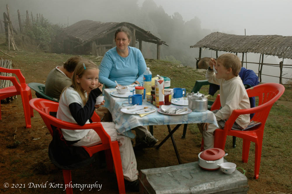
Wangchuck walked with us each day, carrying only a light backpack and an umbrella. The rest of the crew pack up camp, passing us mid-morning so they can provide a hot four-course lunch (with table cloth, plates, and silverware). They pass us again mid-afternoon so we arrive at a campsite all prepared. In late afternoon they bring hot tea and biscuits, and then bowls of warm wash water. A typical dinner is soup, rice, dal, two or three curries, chapattis, and a dessert like fried bananas; always far more than we can eat. Once they even managed pizza! After “bed tea” at 6am, breakfast would be served at 7am; typically, porridge, omelets, toast with jam or honey, tea or instant chocolate. Every day was different food.
Before the trek the company head assured us that the cooks take great care with food preparation, even parboiling the fresh vegies used in a salad. At the first dinner, Pam and I broke our longstanding no-fresh-veggies rule and dug into the salad. Big mistake. Mid-morning the next day I was off in the bushes, exploding from both ends simultaneously. By evening, Pam was struck too. (For once, I am glad the kids did not eat the salad!) This day and the next involved our steep climbs, which I can attest are much slower when one needs to dash off to the woods with a trowel and TP every few switchbacks.
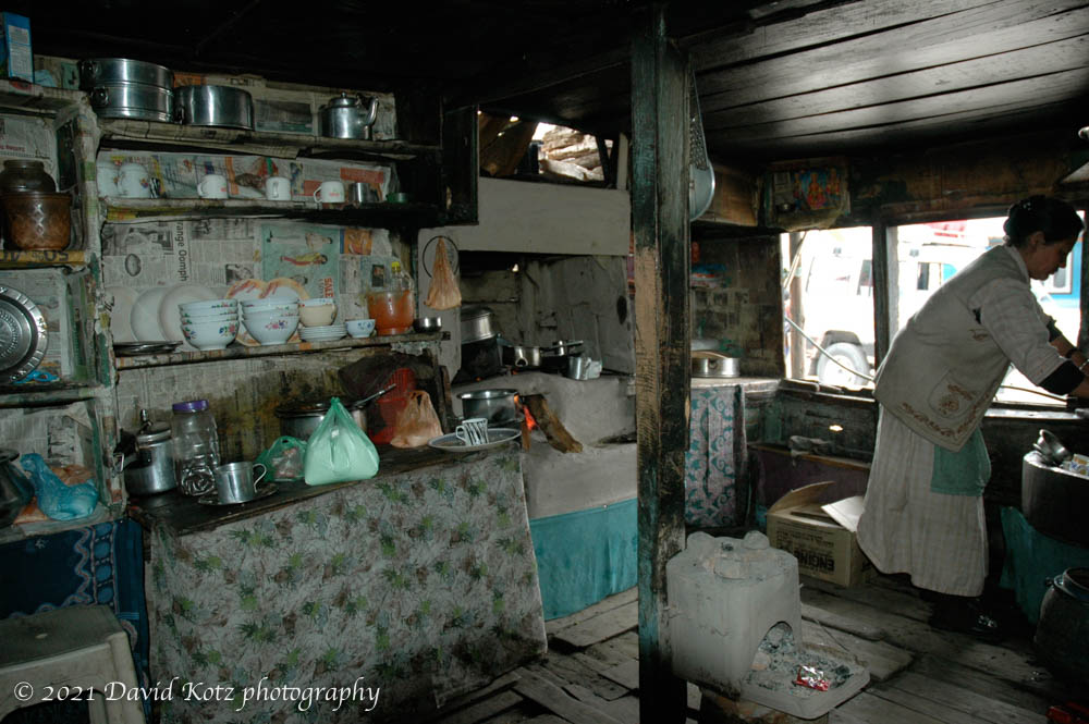
We had the good fortune of visiting several Nepali kitchens, either in small tourist lodges or in individual homes, when the trek borrowed these facilities to serve us lunch or provide us a warm spot to rest before dinner. I’m sure they picked the best ones, but they were always spotless and well-organized; the woman of the house was masterful in her use of a wood-fired stove made of clay and stone.
Each morning I would rise early, perhaps 5:30am, clambering out of the tent in hopes of a clear sunrise view of the mountains. Each time there was dense valley fog, not quite low enough for an undercast, blowing in scrappy bits over the ridge (below). Each day, these low clouds would rise to engulf the ridge by mid-afternoon. Every night it would rain, at least a little; one night it hailed. All this fog and rain feeds many springs, which villagers gather in ad hoc piping systems; I found it odd to see water left constantly flowing from taps outside houses, during the dry season.

Sandakphu, the highest point on our trek (11,929’), was never a village. It arose as a tourist destination, and now boasts three or four lodges as well as a busy outpost for the Indian Army and Forest Service. Andy and I climbed to the top of a hillock above this cluster of buildings, and thus I think we crossed above 12,000’, a personal record. At dawn the next morning I climbed there again, hoping for a view; nothing but whiteout.

On the fourth night we stayed below the ridge, the beginning of our descent. The next morning Wangchuck was kind enough to indulge me in a 2km walk back up to the ridge at dawn, one last chance for a view of Everest. Total whiteout. On the way down, the clouds began to clear, but views of Kangchenjunga remained elusive. After breakfast, I jogged back up the trail a hundred meters… voila! there it was, and I snapped the picture below. Perhaps I’m too view-oriented, but the sight of these big mountains is thrilling and I’m glad I finally got a look.

I was surprised at how little wildlife we saw. We spent most of our time on the ridgetop, of course, and saw little other than the chickens and goats in the village or the yaks grazing in the grasslands. Once we descended into the forests, Pam was lucky to see a Himalayan Marten catching a mouse.

We ended our trek in the village of Rimbick, staying in a hotel there overnight. I saw Wangchuck getting a shave at a tiny stall in the main square (below), and decided to give a try. What an experience! He lathered me up with a brush and then inserted a (thankfully new) razor into his handle. After shaving me twice – those straight razors always make me nervous – he wet a large clear rock and smoothed it over my face. Well, it looked like a rock but I expect it was some sort of soap or disinfectant. Then he dotted my face with pink paste and proceeded with a vigorous face massage. I can safely say this is my first eyebrow massage. The paste left my face tingling while he massaged my scalp and pulled at my hair. He massaged my shoulders, arms, hands, and even fingers, before putting my hand behind my head and then reaching around me to crack my back this way then that. I protested when he went to crack my neck in the same way (cross-reference “broken neck in Fiji” at this point). He combed my hair and wiped my face. Total cost: 50 rupees (a dollar).

I think it is the people that I will remember most from this trip. Nearly all Nepali, they have very different faces than the Indian faces I’m used to, and they were all so friendly. I’m already wondering how I might return.
Be sure to check out the photo gallery!
Itinerary and map
Friday: fly to Bagdogra; drive 3 hours up to Darjeeling (~2200m). Stay at Cedar Inn.
Saturday: Explore Darjeeling. Stay at Cedar Inn.
Sunday: Dodhrey (2590m) to Tonglu (3070m), 7km. Slept in tents on the Nepal side of the ridge, just outside village of Tonglu.
Monday: Tonglu (3070m) to Garibas (2621m) to Kalpokhari (3108m), 12km. Slept in tents in a backyard, ate inside a lodge.
Tuesday: Kalpokhari (3108m) to Sandakphu (3636m), 6km. Slept in the Sunrise Lodge; ate in our room.
Wednesday: Sandakphu (3636m) to Molley (~3200m), 16km. Slept and ate in the tourist lodge at Molley.
Thursday: Molley (~3200m) to Rammam (2560m), 16km. Slept in tents in a home’s front yard, outside the main village.
Friday: Rammam (2560m) to Rimbick (2286m), 16km. Slept in the Hotel Green Hill.
Saturday: drove back to Darjeeling, 4 hours. Explored the market.
Sunday: drove through tea plantations to Bagdogra airport, 3 hours.
This post was transferred from MobileMe to WordPress in 2020, with an effort to retain the content as close to the original as possible; I recognize that some comments may now seem dated or some links may now be broken.

One thought on “Himalayan trek”