
I saved Mount Carrigain for last.
In 2014, shortly after skiing and snowshoeing to the summit of Owl’s Head – one of the peaks in the NH48 (a list of 48 peaks in the White Mountains of New Hampshire whose elevation exceeds 4,000 feet) – I realized that it might be worth hiking all the mountains on that list again. I could aim to complete what I call the “48 over 48”, that is, to hike all 48 peaks on the NH48 list, over the age of 48. After all, I had just completed the most notoriously inconvenient and unrewarding peaks on the list! So why not do all the rest? Read on!
Although I put little energy into this effort in the first few years, because I was busy completing the Adirondack 46 and the Northeast 111 lists, in the past two years I have turned my attention toward finishing this quest. Today, on Mount Carrigain, I finished, just twelve years after my birthday in July 2012.
It is a bit of a silly quest – indeed, some would say any of these box-checking hiking lists are a pointless exercise – but I must say it has been worthwhile. Although there are some peaks on the list I visit often, because they are favorites (like Moosilauke, which I’ve summited over 100 times) or are close to home and offer great views (like Lafayette), this 48-over-48 quest has broadened my horizons, and brought me back to many mountains and trails I had not visited since the 1980s. After a gap of thirty or forty years, it was a new experience; they felt like new mountains to me!
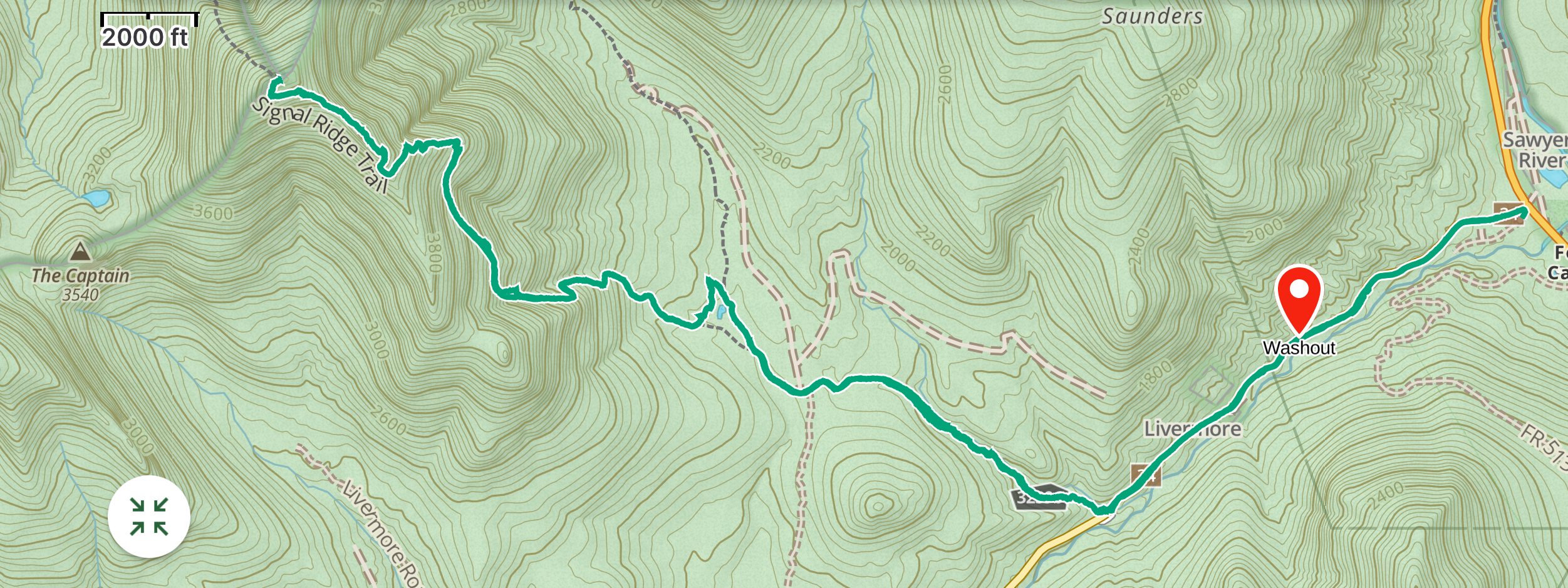
In 2024 I’ve knocked off Moriah, Willey Field and Tom, South Twin and Galehead, Cabot, and Isolation. At 8am today, I met my dear friends David and Kathy to make the final ascent: Mount Carrigain. The standard route to Carrigain is up the Signal Ridge Trail, which is a pleasant 5.2-mile hike from Sawyer River Road, a dirt road maintained by the US Forest Service; unfortunately, a major washout last December caused them to close the road, adding a 2.0 mile road-walk to the route, thus creating a 14.4-mile round-trip hike. Fortunately the road is a gentle climb, and went quickly. About halfway, we passed the place where heavy rains had washed away half the road, and leaving the rest of the roadbed quite vulnerable.

to reach the trailhead.
We reached the Signal Ridge Trail and began the long five-mile hike toward the summit. The first couple of miles are very gentle, sometimes following the pretty Whiteface Brook and soon crossing the more rambunctious Carrigain Brook. At that crossing, we encountered a group of Harvard first-year undergraduate students packing up their camp; they were out for a six-day backpacking trip as part of their “experiential orientation” activity before classes start in a few weeks.

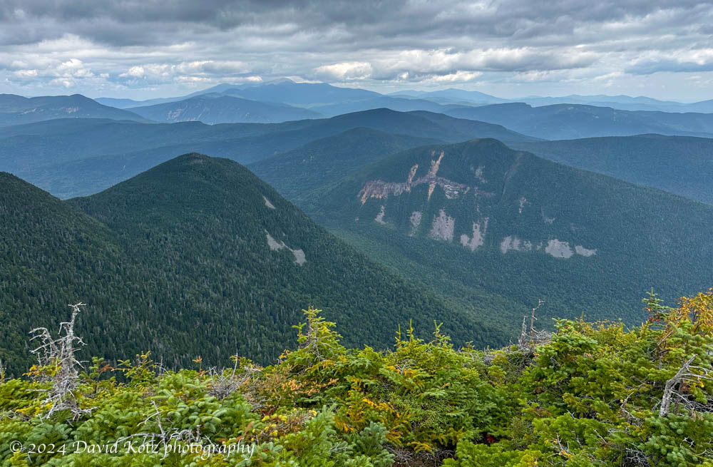
The trail started to climb, steadily at times, and steeply at times, switch-backing up the valley slope toward Signal Ridge, away from the deep and craggy Carrigain Notch. This strenuous section, over two miles, was a real grunt – so we were glad when we reached the ridgeline where it broke open to views of Carrigain Notch in the foreground and Mount Washington and the Presidentials in the distance. We could also see the summit of Mount Carrigain, topped by its observation tower, ahead.

which is topped by an observation tower.
That final climb – after six lengthy miles of hiking – was especially tough… so we were relieved to settle in atop the tower to soak in the views, eat our lunch, and snap some celebratory photos. Chocolate-chip cookies made it special!

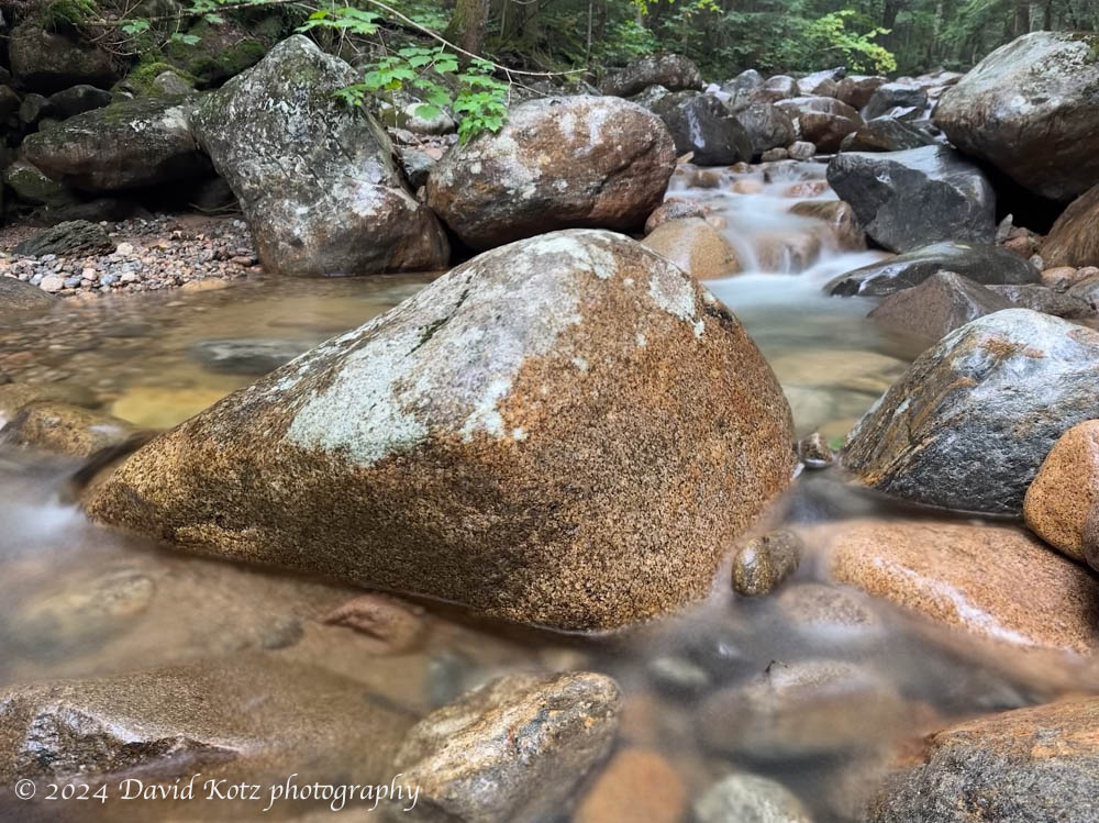
Satiated, we donned our packs for the long walk back. We made it about two miles before thunder first made itself known – and the drizzle began. Fortunately, the weather was calm and warm, and the trees sheltered us from most of the rain, allowing a pleasant walk out despite the drips and drops from above. As we reached the end of the trail, I took the opportunity to photograph Whiteface Brook.
Check out the gallery for more photos, including a summit panorama.
Hike stats (Carrigain):
Distance: 14.4 miles (23.2km)
Time: 9h18m (including stops)
Gain: 3,690′ (1125m)
Thanks: Many thanks to those who accompanied me for about two-thirds of the NH48 mountains: Aarathi, Alex, Andy, Claire, David, Jeff, Jen, John, Jon, Kathy, Ken, Kristin, Lars, Lelia, Shrirang, and Tim. Your support and companionship made it all the more enjoyable!

One thought on “Carrigain: 48 over 48”