One of the largest and most iconic waterfalls in Iceland.
Part of a series of posts about my travel in Iceland, including visits to eleven waterfalls.
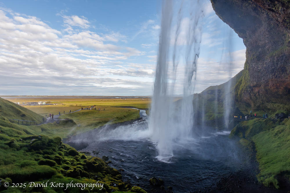
Likely one of the most recognizable waterfalls in Iceland, at least outside those within the Golden Circle, Seljalandsfoss is a massive, free-falling, overhanging waterfall visible from 50km away as you drive the Ring Road. An extensive (and crowded!) carpark corrals the tourists as they stream toward the short trail up to the falls. I purposely arrived early, around 8:30am, in hopes I might beat most of the tourists coming from Reykjavik. I did, but there were nonetheless over one hundred people already there, each angling for a selfie or family photo. This waterfall is especially exciting because one can walk up to, and behind, the waterfall. Read on!
Wading into the icy water led me to better photos!
Part of a series of posts about my travel in Iceland, including visits to eleven waterfalls.
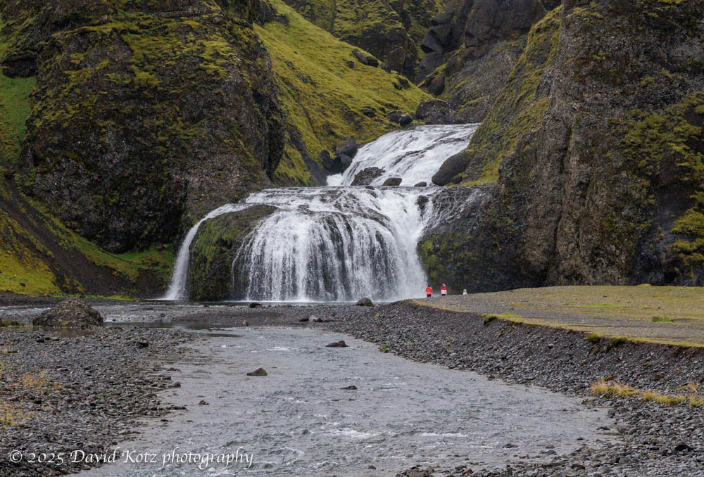
Stjórnarfoss was unusual among all the falls I visited – hardly anyone else was there. In my half-hour on site, perhaps a dozen people came by to snap their photos. In the photo below, the presence of a few people give you a sense of scale for this two-tier waterfall. Here I deployed my secret weapon: water sandals, which I used at about half of the waterfalls on this trip. The water was cold, and lapped at my rolled-up pants, but the opportunity to wade shin-deep allowed me access to compositions impossible for those who needed to keep their feet dry! Read on…
Part of a series of posts about my travel in Iceland, including visits to eleven waterfalls.
Svartifoss waterfall is impressive, in part for its 20-meter free-fall from the cliffs at the head of a deep gorge. The horseshoe-shaped wall behind the falls is made of columnar basalt, providing a dark, geometric backdrop to a dazzling chaotic flow of whitewater. Hundreds – if not thousands – of tourists hike the short trail to these falls, pausing on a low bridge across the stream below the falls, or on a metal platform cantilevered on the cliff off to one side. Signs ask people not to approach the falls at water level, but with some careful maneuvering I was able to find a spot where I could balance myself on boulders, place my tripod feet in the stream, and get some clear shots. In the photo below, I include a person on the viewing platform at right; although they are closer than the falls, it provides some sense of scale. Read on…
Part of a series of posts about my travel in Iceland, including visits to eleven waterfalls.Iceland is a magical place for anyone who loves waterfalls. The steep terrain, birthed from volcanoes and shaped by glaciers, leads to steep slopes and differential weathering that creates massive cliffs and deep gorges. Plentiful rain and glacial meltwater result in massive water flow that leaves visitors with a sense of wonder – and soaking wet clothes. For each the next 10 days I will share photographs from one of the eleven waterfalls visited on this trip.
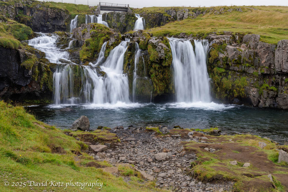
I’m sneaking Kirkjufellfoss into my post-Greenland posts, although we actually visited it ten days earlier at the beginning of the cruise to Greenland. We spent a cloudy morning visiting these falls and walking a gravel path back to town, where our ship was docked. These falls, near the Kirkjufell volcano on the Snæfellnes Peninsula, are a favorite subject of photographers. (Mount Kirkjufell is often noted as the ‘most photographed mountain in Iceland.’) As with many of Iceland’s waterfalls, it is particularly challenging to capture this beautiful waterfall without a lot of people in the shot. In this case, the pathway for visitors literally passes above the falls on a low bridge across the stream, meaning any upstream shot inclusive of the whole cascade is bound to include the bridge and, today, several other tourists. Patience, and careful composition, led me to some decent shots. Read on…
Massive glaciers spill ice into a tidal lagoon – ice that washes ashore on a black-sand beach. Spectacular!
Part of a series of posts about my travel in Iceland, including visits to eleven waterfalls.
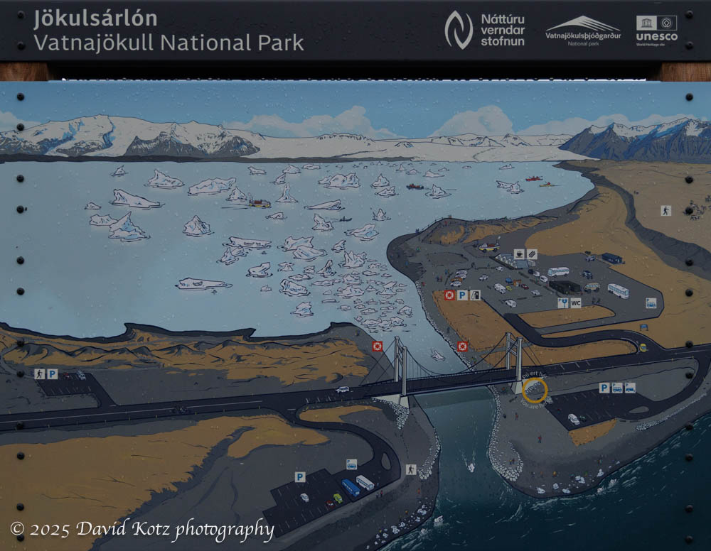
Although the trigger for this visit to Iceland was to board the National Geographic Endurance for an expedition cruise to southern Greenland, photography was the focus of my extended stay in Iceland. This post highlights photos from my first stop in Iceland: Jökulsárlón (aka Glacier Lagoon) and its adjacent Diamond Beach. While I’m at it, Fjallsárlón lagoon is just down the road and offers equally enthralling scene of an adjacent glacier calving bergs and berglets into a tidal lagoon. Read on to see photos!
A spectacular gorge with a pretty waterfall at its head.
Part of a series of posts about my travel in Iceland, including visits to eleven waterfalls.
Although Fjaörárgljufur ravine includes several beautiful cascades, it is best known for its deep and spectacular gorge. When I visited, on the afternoon of my first day, it was teeming with other visitors who hiked the trail on the high terrain for its various views across and down into the gorge. The trail ends at a precarious viewing platform overlooking Mögárfoss, a tall waterfall at the head of the ravine. Read on…
One might imagine becoming stir crazy during ten days aboard ship. Fortunately, the expedition team offered many opportunities to go ashore! Nearly every day they would offer short, medium, and long walks. Some were billed as a ‘photo walk,’ accompanied by the ship’s photo experts; others were focused on interpretation of the ecology or history; still others were pointedly called a ‘strenuous hike’ for which exercise was the goal and there would be no time to stop for photos or natural-history lessons. We were fortunate with good weather – sometimes fantastic weather – so I had the opportunity to hike at Dronning Marie Dal (in Skjoldungensund), at the outlet of the Sermeq glacier (at the head of Tasermiut fjord), around the Hvalsey historic site, around the village of Qassiarsuk, and in the tundra above Neria fjord. The scenery was dramatic, and varied tremendously from place to place. Read on for more!
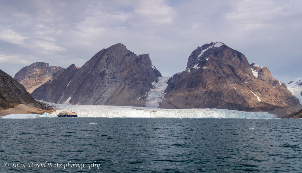
It’s hard to imagine the size of Greenland, or its ice cap. Even those glaciers that flow down to the sea, like the Thryms glacier below, are truly massive. (Notice our ship, the National Geographic Endurance, at lower left!) Read on for more about our outings among the ice, including video…
Although our route sometimes had the Endurance sailing offshore overnight south along the eastern coast, and sailing north along the western coast, most of our time in Greenland was spent in the extensive fjord systems that shape the southern tip of Greenland. In this landscape, a visitor can understand why the early Norse settlers named this land Grœnland (green land) when the Norse, led by Erik the Red, settled here in 982. Although these fjords have steep walls and deep waters, their shores and (rare) shallow glacial plains are covered in a green, grassy tundra sprinkled with heather, dwarf willow, dwarf birch, crowberries, blueberries, and a variety of wildflowers. Although “Iceland’s landscape is the world’s youngest and most dynamic, the rocks of Greenland are the oldest yet discovered on the planet.” [NatGeo] Read on for more…
Shortly after dinner on our first night aboard, as we cruised the Iceland coast toward its western peninsulas, the ship’s naturalists – always on the lookout – announced we had come upon a group of whales. It turned out to be a pod of minke whales and a bubble-feeding humpback whale. The ship paused as passengers enjoyed watching the humpback, right next to the ship, repeatedly blew a circle of bubbles, and then surfaced in the middle to swallow a massive gulp of fish that it had ‘trapped’ in the confused circle created by the bubbles. I stood on Deck 6 forward, capturing snaps of the smaller minke whales in between sightings of the humpback. Check out the gallery of my images, and watch a video, including some from the moment below captured by National Geographic photographer Nick Cobbins. Read on for more…