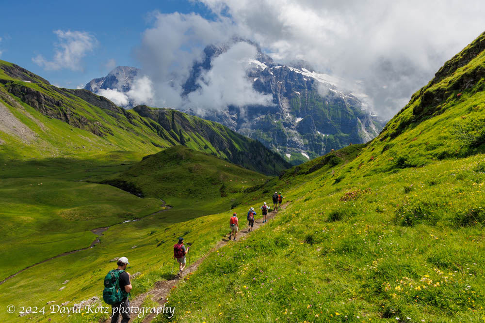
A gentle hike from Gross Scheidegg down to Schwarzwaldalp.
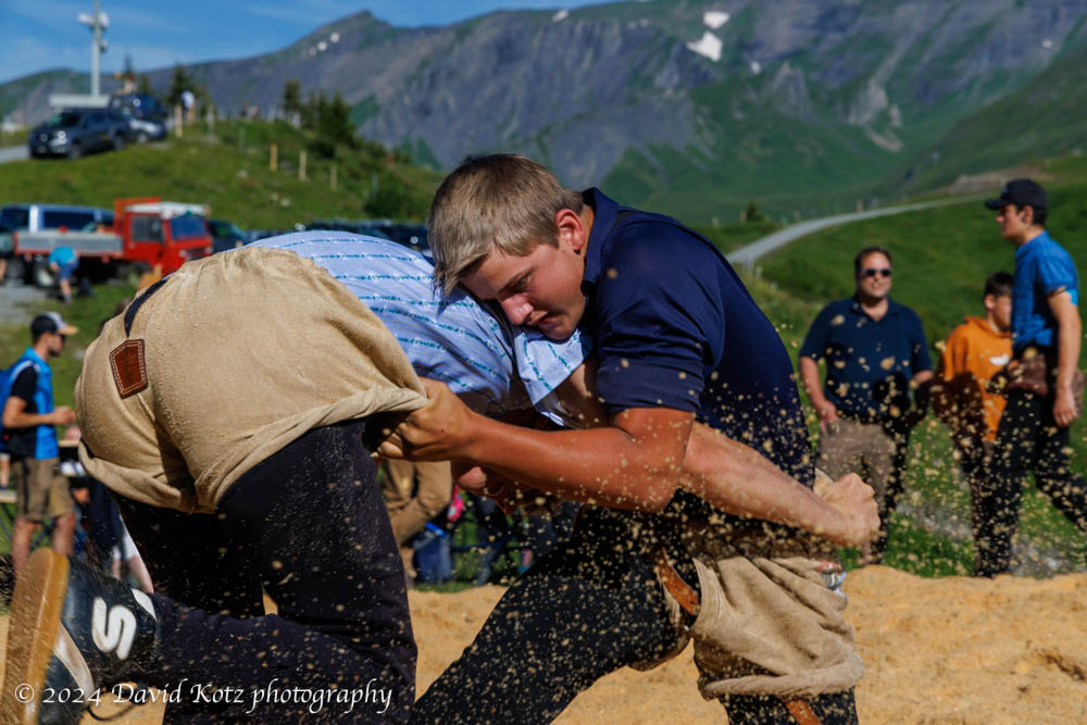
On our final day in Grindelwald, we chose a milder hike. It began with a bus ride up the steep and winding road to a mountain pass, Gross Scheidegg – the taller (eastern) counterpart to Kleine Scheidegg on the western side of Grindelwald. Here we stumbled into a local community festival, which appeared to be an amateur wrestling contest! We stopped to watch for a while, then ambled up the road and along the trail to take us down the other side of the pass. Our goal was the tiny village of Schwarzwaldalp, which we understood to be the site of a historic, water-powered sawmill. Read on!
An afternoon jaunt to a promontory overlooking Grindelwald.
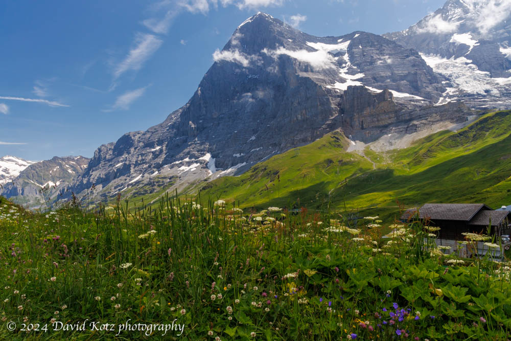
Our fourth day in Grindelwald allowed for a second hike. (In the morning, most of us took the train up to Jungfraujoch, where three of us walked through the sunshine across the snowfields to a hut for tea and cakes.) On return to Kleine Scheidegg, we met up with others in our group for lunch at a cheerful little berghaus nearby. We then struck out along the ridgeline, with the Eiger’s north face dominating the landscape behind us. Read on!
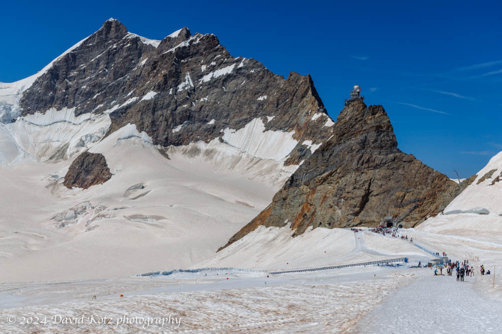
A morning visit to the highest train station in Europe – and a stroll across the snowfields at 12,000′.
On our fourth day in Grindelwald we took two hikes. We spent the morning visiting Jungfraujoch, which (despite its intensely touristy nature) is an incredible place to visit. It is the highest train station in Europe, serving a structure that perches on a pinnacle at 3571m (11,716′) above sea level, adjacent to the snowfields surrounding the 4000m Alpine mountains of Eiger, Mönch, and Jungfrau. In this post I share a few impressions – and a gallery of photos of our walk across the snowfield to the hut at Mönchsjochütte, on an astonishingly gorgeous day.
On the third day of our week in Grindelwald we decided to hike one of the most classic routes in the area, from Schynige Platte to First – although in the opposite direction. My hike there in 2019 was one of the most moving hikes I’ve ever experienced, as the Alps emerged out of an undercast sky like so many islands in an endless sea. Today, I was thrilled to share it with friends!
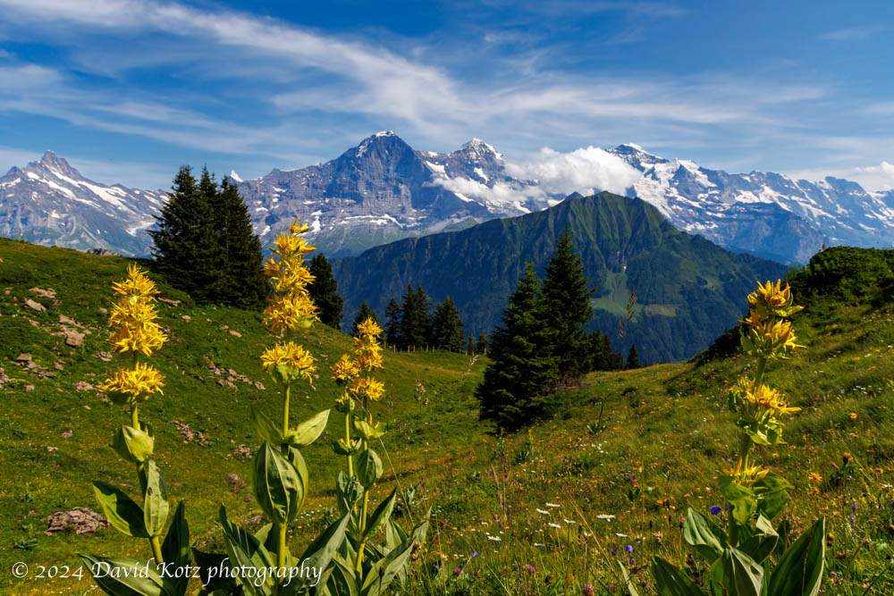
Today, we hiked from First (reached by gondola from downtown Grindelwald) to Schynige Platte (reached by a historic cog railway that climbs into the mountains from a valley close to Interlochen). The weather was perfect, so we were treated to a day full of stunning vistas as we hiked the high country above Grindelwald, over the pointy peak of Faulhorn (with lunch at its summit hotel!), along the rocky ridgeline, through alpine meadows brimming with wildflowers, across a couple of stubborn snowfields, and past another hut at Männdlenen (with a stop for apfel strudel, of course!). Read on, and check out the gallery.
Stunning views from our walk toward some glaciers above Grindelwald.
For the second hike of our week-long visit to Grindelwald, we chose the opposite side of the valley, a deep canyon formed by the Ischmeer Glacier, whose remnants cling to the high slopes of 4000-meter peaks like Schreckhorn, Finsteraarhorn, and Feischerhorn. Our primary goal was the Berghaus Bäregg – literally, mountain house at bear corner – which we rightly anticipated would provide a sunny lunch spot with spectacular views of the glacier. Our stretch goal was to continue onward to Schreckhornhütte, another hut far upslope at elevation 2,527m. Although we turned around when we reached 6,000’ (1829m) we enjoyed the sunny meadows strewn with wildflowers; views of glaciers and snowfields spawning massive waterfalls and cascades; and challenging sections of trail where it clung to the cliffside or crossed massive washouts. And, a hearty lunch at the Berghaus! Read on, and check out the gallery.
Our first hike above Grindelwald brought us out of the clouds and into spectacular scenery.
Our first hike out of Grindelwald was a relatively low-altitude stroll across the high terrain above town, from the end of the bus line at Bussalp to the end of another bus line at Waldspitz. The sky was cloudy as the bus wound up the steep and twisty road from Grindelwald, past the holiday homes and into the farm country high above town. Still, the clouds looked like they were struggling to hold form as the daylight grew stronger, so we headed up the trail in high spirits. Soon we were following a narrow track that meandered among the cows, across streams, and through meadows strewn with wildflowers. The clouds began to dissipate and the incredible peaks of Eiger, Mönch, and Jungfrau peeked out from across the valley. Read on, and check out the photos!
My first visit to Grindelwald was in fall 2019, after an incredible overnight stay at the alpine hut perched on the summit of Faulhorn mountain, with sunset views of the Eiger, Mönch, and Jungfrau. It was so stunning that I brought my family back there in December, to see it in winter – and then again in June 2020, to hike from there up to Kleine Scheidegg in the shadow of the Eiger. Each visit to Grindelwald was magical, surrounded as it is by the stunning beauty of the Alpine peaks and pastoral meadows. So, despite its intense tourism (after all, I am hardly the first person to notice Grindelwald!) I decided Grindelwald would be an excellent base for a week of hiking with college friends. We rented a house on Vrbo, and settled in on Monday evening for a week-long stay.
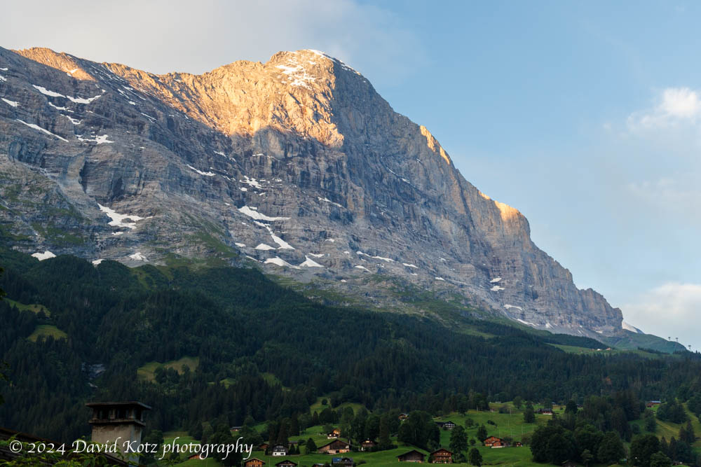
View of the Eiger’s north face, from the bedroom balcony of our rental house.
In subsequent posts I will highlight each of our daily hikes, then wrap-up with a few photos of Grindelwald itself.
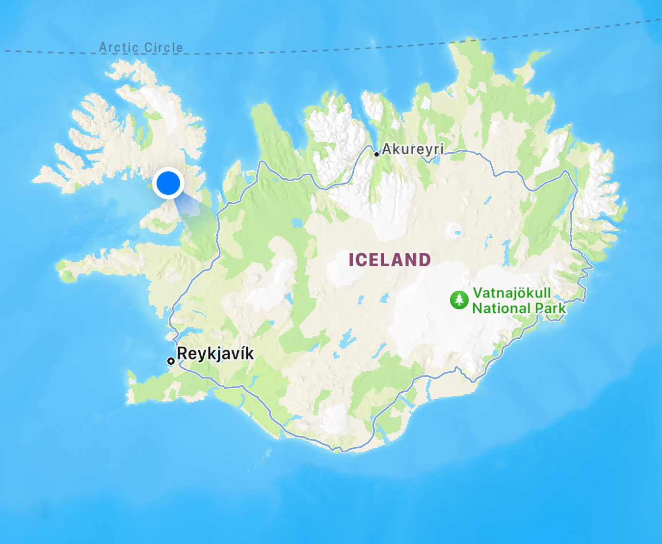
A beautiful two days in the remote northwestern region of Iceland.
After a few days amongst throngs of tourists at the “Golden Circle” of sights near Reyjavik (see my prior post) we headed for the remote northwestern corner of Iceland, the Westfjords. We rented a rural house at the blue dot on the map below, and explored westerly from there – reaching the westernmost tip of Iceland, which is also the westernmost point in Europe. It required driving some remote, dusty, narrow, twisty, and sketchy roads… but also led us to stunningly beautiful landscapes. Read on! and check out the galleries linked below.
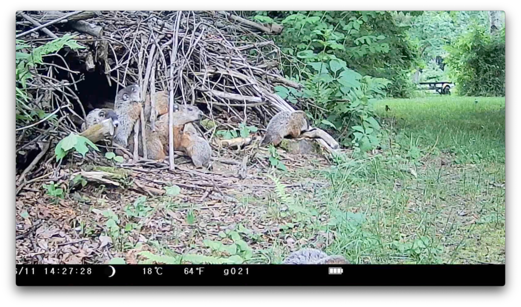
Far in the back of our backyard is a pile of sticks – woody debris we’ve piled up for over 25 years as we trim trees and clear brush. With time, the pile has decomposed and compressed into a thick, firm dome-shaped structure. Last fall I discovered that some critter had burrowed under the pile. This spring I placed one of my wildlife cameras a few feet from the entrance and, in early June, I started capturing video of a big fat groundhog (woodchuck) emerging from the burrow. Then one day, I saw tiny faces appear deep in the burrow. Within a day, seven groundhog pups were exploring the burrow’s “front yard.” Wow, do these little pups have energy! Mama would come and go, presumably to feed (and perhaps to catch a little ‘me’ time), and sometimes to bring back a mouthful of dried leaves to freshen up the interior of their home. Meanwhile, the pups would play, wrestle, climb, and explore. I collected hundreds of minutes of video capturing some fascinating behaviors; here, I edited it down to an eight-minute compendium of my favorite clips. Settle in for eight minutes, and enjoy the video!
An hour wading among wildflowers on a summer morning.
A meadow near our home has been planted with wildflowers, bringing smiles to everyone who rides or drives by. One foggy morning I spent a happy hour collecting photographs as the sun rose and started to burn off the fog. Check out the full photo gallery!
Wildflowers along River Road in Lyme.
Many thanks to the Upper Valley Land Trust (UVLT) for conserving this former farm field, and to the landowners for planting beautiful wildflowers!
All images shot with Canon R5 with the RF 100-500 lens.