Grindelwald – Berghaus Bäregg

Stunning views from our walk toward some glaciers above Grindelwald.

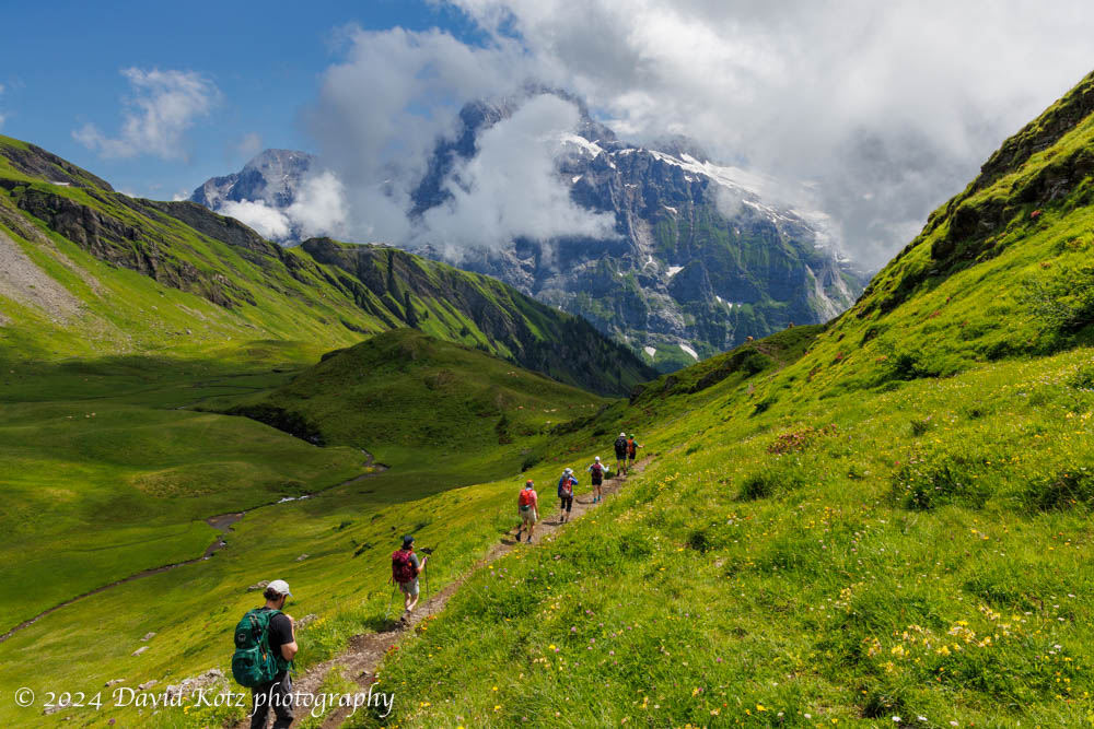
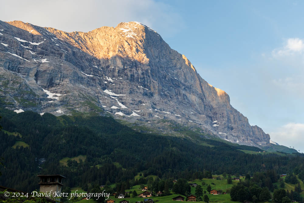
For the second hike of our week-long visit to Grindelwald, we chose the opposite side of the valley, a deep canyon formed by the Ischmeer Glacier, whose remnants cling to the high slopes of 4000-meter peaks like Schreckhorn, Finsteraarhorn, and Feischerhorn.  Our primary goal was the Berghaus Bäregg – literally, mountain house at bear corner – which we rightly anticipated would provide a sunny lunch spot with spectacular views of the glacier.  Our stretch goal was to continue onward to Schreckhornhütte, another hut far upslope at elevation 2,527m.  Although we turned around when we reached 6,000’ (1829m) we enjoyed the sunny meadows strewn with wildflowers; views of glaciers and snowfields spawning massive waterfalls and cascades; and challenging sections of trail where it clung to the cliffside or crossed massive washouts.  And, a hearty lunch at the Berghaus!  Read on, and check out the gallery.

View from Berghaus Bäregg, toward the Ischmeer glacier; the trail continues level across the green slope at left and around the corner.
Continue reading “Grindelwald – Berghaus Bäregg”

Grindelwald: Bussalp to Waldspitz

Our first hike above Grindelwald brought us out of the clouds and into spectacular scenery.

Our first hike out of Grindelwald was a relatively low-altitude stroll across the high terrain above town, from the end of the bus line at Bussalp to the end of another bus line at Waldspitz. The sky was cloudy as the bus wound up the steep and twisty road from Grindelwald, past the holiday homes and into the farm country high above town. Still, the clouds looked like they were struggling to hold form as the daylight grew stronger, so we headed up the trail in high spirits. Soon we were following a narrow track that meandered among the cows, across streams, and through meadows strewn with wildflowers. The clouds began to dissipate and the incredible peaks of Eiger, Mönch, and Jungfrau peeked out from across the valley. Read on, and check out the photos!

Descending through a verdant valley, with alpine peaks looming ahead.
Continue reading “Grindelwald: Bussalp to Waldspitz”

Grindelwald

Home base for a week of alpine hiking!

My first visit to Grindelwald was in fall 2019, after an incredible overnight stay at the alpine hut perched on the summit of Faulhorn mountain, with sunset views of the Eiger, Mönch, and Jungfrau. It was so stunning that I brought my family back there in December, to see it in winter – and then again in June 2020, to hike from there up to Kleine Scheidegg in the shadow of the Eiger. Each visit to Grindelwald was magical, surrounded as it is by the stunning beauty of the Alpine peaks and pastoral meadows. So, despite its intense tourism (after all, I am hardly the first person to notice Grindelwald!) I decided Grindelwald would be an excellent base for a week of hiking with college friends. We rented a house on Vrbo, and settled in on Monday evening for a week-long stay.

View of the Eiger’s north face, from the bedroom balcony of our rental house.

In subsequent posts I will highlight each of our daily hikes, then wrap-up with a few photos of Grindelwald itself.

Iceland – Reykjavik and Golden Circle

Our week in Iceland began with a tour of some classic sights.

Our extended family loves to travel. We sought an interesting destination to celebrate a graduation and two birthdays, and settled on Iceland. So eleven of us met up in Reykjavik for a busy week of touring this beautiful country. Iceland’s northernmost point just grazes the Arctic Circle, but even at Reykjavik (on the southwest coast) and on our dates (three weeks after solstics) the days were still very long: sunrise at 0342 and sunset at 2325; it was never dark! Although Iceland is a small island, a one-week visit is really only enough to scratch the surface – we focused on the area around the capital of Reykjavik (and the crowded “Golden Circle” of nearby sights) and the remote Westfjords peninsula. This post focuses on the Reykjavik area; see the combined gallery or the location-specific galleries below. Read on!

Continue reading “Iceland – Reykjavik and Golden Circle”

Mount Cabot and The Horn

Bagging another two peaks – one NH48 and one 52WAV.

After bagging some of the more prominent New Hampshire peaks three days ago – in the Pemigewasset Wilderness, at the heart of White Mountain National Forest – I was still itching for another hike on this long holiday weekend. So early today my son and I headed back north, through the fog lining the Connecticut River Valley. We passed through the Sunday-morning quiet in small towns like Groveton and tiny towns like Stark, ending up on a remote gravel road leading to the New Hampshire Fish Hatchery near York Pond. As the sun struggled to beat back the morning fog, we dove into the damp, green forests below Mount Cabot. Our goal was an 11.5-mile triangular loop over Cabot and another less prominent – but more promising – bump called The Horn. Read on!

View from the summit of The Horn back toward Mount Cabot (at center) and The Bulge (at right).
Continue reading “Mount Cabot and The Horn”

Galehead and South Twin

Two more 4000-footers, on July 4th!

The July 4th holiday provided me an opportunity to get back to the White Mountains, to revisit some peaks I had visited on my first days as a college student in 1982. The weather forecast looked good, and although a brief sprinkle spritzed my car as I approached the trailhead, spirits were high as I met up with two friends and their two dogs. Our goal was to climb two of New Hampshire’s 48 four-thousand-foot peaks: South Twin, and Galehead. We succeeded and had some fantastic views along the way. Read on!

The Gale River, along the Gale River Trail to Galehead hut.
Continue reading “Galehead and South Twin”

Maroon Bells

Photographing one of the most iconic mountain scenes in North America.

This being my first visit to Aspen, I spent the past few months asking friends and colleagues where I should plan to hike.  Although there were many great suggestions, I had only one day I could fully allocate to hiking.  From my research, it was eminently clear that the Maroon Bells are a must-see destination.  Fortunately, they are easy to reach from Aspen, with a free city bus from Aspen town over to the base lodge of the Aspen Highlands ski area – which in summer serves as the base for the shuttle bus up the Maroon Creek valley to Maroon Lake and its trailhead. Read on and be sure to visit the photo gallery!

Maroon Bells and Maroon Lake, Colorado.
Continue reading “Maroon Bells”

Aspen Mountain

A steep climb at high altitude, with outrageous views.

I was in Aspen for a AAA&S workshop for higher-ed leaders; immediately afterward, I pulled together my hiking and photography gear and took the hotel shuttle into the center of town.  From there, I walked a kilometer on city streets to reach the trailhead for the Ute Trail, which leads up to Ute Rock and beyond to the summit of 11,270’ Aspen Mountain (3435m).  I was fortunate to have arrived in Aspen three days earlier, to give me a little time to acclimatize to Aspen’s 7,980’ elevation (2432m).  Still, especially under the afternoon’s strong summer sun, I really felt the altitude as I climbed the incredibly steep trail through eight, nine, ten thousand feet.  The first half of the route ascends on steep switchbacks through a forest of aspen and conifers, with wildflowers sprinkling the forest floor; it then follows ski slopes (black diamond and double-black diamond!), some with lingering patches of snow, to the summit.  Three thousand feet of gain in under three miles, at this altitude, whew!

I take in the view from the sundeck at the summit.
Continue reading “Aspen Mountain”

Aspen

My first visit to Aspen – beautiful!

I had the opportunity this week to attend a Forum for Higher Education Leaders, hosted by the American Academy of Arts & Sciences (AAA&S), in Aspen, Colorado.  I had never been to Aspen before… but the opportunity to spend a week in the Rocky Mountains, during wildflower season, was too much for a hiker/photographer like me to pass up.

View down to center of Aspen, along my route down Aspen Mountain.
Continue reading “Aspen”

Willey, Field, and Tom

A three-fer of four-thousand-footers.

In my continuing effort to re-visit some of New Hampshire’s tallest peaks – those 48 peaks over four thousand feet – I joined two friends today to walk the forested range on the west side of Crawford Notch: Mounts Willey, Field, and Tom. This threesome offers a steep climb, a pleasant up-and-down ridge walk, and a few spectacular views to the east (the southern Presidential Range, including Mount Washington), to the west (the Pemigewasset Wilderness), and to the south (Mount Carrigain and the peaks along the Kancamagus Highway). Check out the photo gallery, and read on!

View of Mount Washington and the Presidential Range, with Crawford Notch and Webster Cliff in the foreground, from Mount Willey – NH.
Continue reading “Willey, Field, and Tom”